
Tuesday NJ weather: Not as hot, still very humid, with only spotty thunderstorms
The Bottom Line
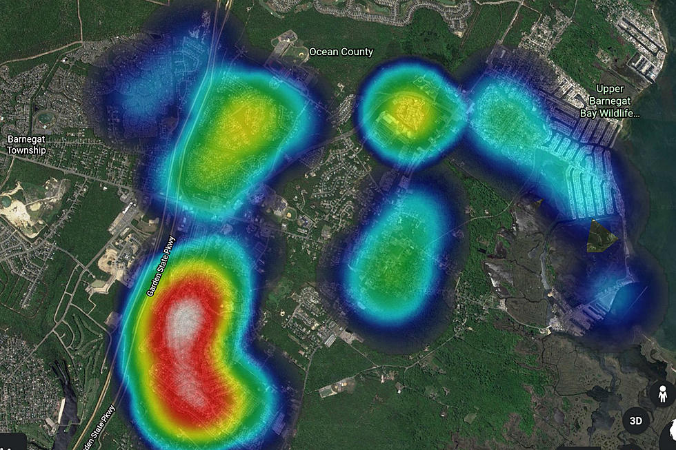
As expected, explosive thunderstorms brought a variety of severe weather to New Jersey on Monday, ranging from areas of 4+ inch rainfall to ping-pong ball size hail to wind gusts as high as 66 mph (Berkeley, Ocean County) to a waterspout (Stone Harbor, Cape May County). Tuesday will be a bit calmer, and a bit cooler. Having said that, humidity will be very high, so you're still going to sweat. And we are facing some spotty popcorn convection too.
Tuesday
Areas of light fog have developed where it really poured on Monday. Under partly to mostly cloudy skies, high temperatures are forecast to reach the mid 80s — we may very well miss 90+, capping our heat wave at 5 days.
In addition, spotty showers and thunderstorms are expected to pop up in the afternoon and evening hours (let's say 1 p.m. to 8 p.m.) There's no major storm system in play here, just some weak boundaries left over from Monday. Storms will be less widespread than on Monday. And the risk for flooding and severe weather is not zero, but it will be relatively low. Just some raindrops and rumbles of thunder.
Tuesday night will be partly cloudy and sticky, as low temps only dip into the lower 70s.
Wednesday
Skies look mostly cloudy, with highs climbing into the warmer-than-normal upper 80s. Some model guidance is pumping out scattered thunderstorms late-day, mainly to the north and west. The chance for rain closer to the coast is pretty slight — it's a matter of timing, as showers look to fizzle as they traverse the state.
Taking Care of Business: Wednesday at 7 p.m., Eric Scott leads a discussion on how to support businesses — and how they can keep you safe as they reopen in the pandemic. Listen on New Jersey 101.5 FM, the NJ 101.5 app or NJ1015.com, and join the discussion in real time at Facebook.com/NJ1015.
Thursday
Mostly sunny and probably dry — a nice, hot summer day. High temperatures will return to near 90.
Friday
A storm system sliding up the coast comes into the picture Friday morning. (That system may develop some tropical characteristics, so it's important to monitor this one carefully.) At the moment, I'm seeing some rain and wind (30+ mph gusts), especially for the Jersey Shore. Previous guidance has suggested an extended period of heavy, tropical rainfall. At the very least, we'll see lots of clouds and therefore cooler temperatures. Highs on Friday look to be limited to the lower 80s, at the warmest.
Saturday
Wow, we're already talking about the weekend again?! There's a slight chance (according to the Euro model) that Friday's storm system will still be in the neighborhood Saturday morning, so I have to include a slight chance for a shower. Otherwise, we'll be heating up again for the second weekend of July. Highs will push into the 90s for most of New Jersey (including mainland beaches), under mixed clouds and sun.
The Extended Forecast
The heat looks to hold through Sunday and Monday — that would make it 3+ days in a row, and that would make it another official heat wave. No major storm systems, cooldowns, or "dangerous" heat ridges on the horizon.
More From 105.7 The Hawk


![Watch Wild Weather Move Through Toms River [Video]](http://townsquare.media/site/394/files/2020/07/Lightning-July-6.jpg?w=980&q=75)