
Winter Weather Advisory: A slushy mess for NJ by Wednesday morning
I do not have any significant forecast changes or notable updates to share. However, I think it's important to hammer home some important points and provide an easy-to-skim guideline of New Jersey's descent from wet and warm to wintry and white.
The Bottom Line
This will not be a major winter storm for New Jersey. But the timing is just terrible, with the heaviest and most widespread snow coinciding with the Wednesday morning commute. It is going to get messy, because of low visibility and/or slushy conditions. School delays are probable, and even closures are possible, depending on exactly how white and slippery things get in the morning.
Just don't let this burst of wintry weather take you by surprise.

Winter Weather Advisory
A Winter Weather Advisory goes into effect from 3 a.m. to 11 a.m. for the northeastern corner of New Jersey: eastern Bergen, eastern Essex, Hudson, and eastern Union counties. An advisory is issued for minor snow and ice accumulations, which could lead to some travel issues — it is not as severe or urgent as a warning.
Timeline
With temperatures still in the 50s for a good part of New Jersey this afternoon, I realize it's hard to believe wintry weather is less than 12 hours away. Needless to say, the change to colder 30s is going to be very noticeable.
—6 p.m. Tuesday... It will be another wet evening commute, as scattered rain passes through New Jersey. (Not as heavy or steady as Monday, thankfully.) While temperatures will still be in the 50s for most, thermometers will really start to fall sharply during the evening hours.
—10 p.m. Tuesday... The atmosphere will cool sufficiently in NW NJ to allow for first snowflakes to mix in. Most of the state is still wet and not wintry at this time.
—2 a.m. Wednesday... By this point, the freezing line should be approaching the NJ Turnpike corridor. Mainly light-moderate snow to the north and west, mainly rain to the south and east. (The transition from rain to snow will probably have some sleet or mix in the middle, by the way.) The ground will probably start getting slushy at this point.
—6 a.m. Wednesday... Prime time, as even the southern coast of New Jersey switches to at least wintry mix. (Although NW NJ will find itself on the edge of the storm, allowing the snowfall to taper off considerably there.) Models also suggest this will be the time of heaviest wintry precipitation for most of the Garden State. (Heavy snow is defined as reducing visibility to less than a quarter-mile.) Just in time for the morning rush.
—10 a.m. Wednesday... As our storm system departs, snow will continue to taper off in the late morning hours. Skies will clear to sunshine through the afternoon, although temperatures will remain cold in the 30s.
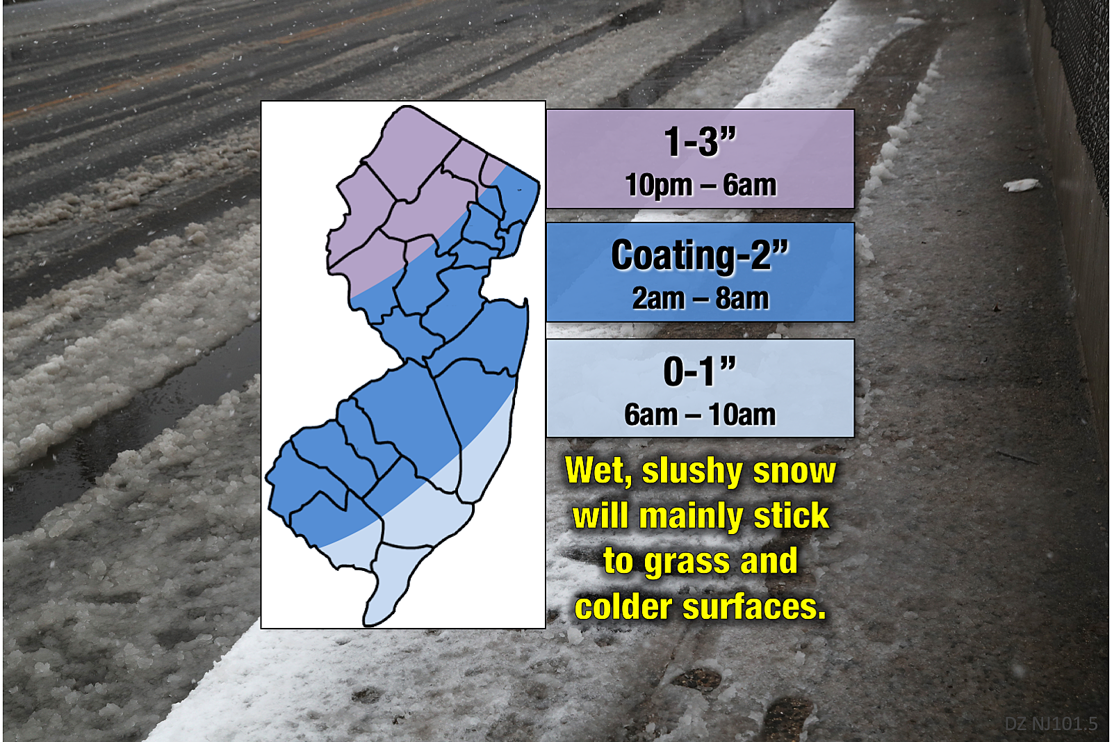
Totals
As I have mentioned in previous weather blog articles, I am reasonably confident everyone in NJ will see snow falling from the sky.
Whether or not that snow will stick and accumulate to the wet and (relatively) warm ground? It's really just an educated guess. (Then again, that's the case with most weather forecasting.) Grassy areas and low-traffic side streets have the greatest potential for some slush and snow by Wednesday morning.
—1 to 3 inches of snow/sleet/slush for northwestern New Jersey. Here, the rain-snow transition is expected to happen before Midnight. The ground is also just a bit colder too, making even road surfaces more conducive to snow accumulation.
—A coating to 2 inches of snow/sleet/slush for the stripe through the middle of the state, between the mountains and the coast, on either side of the NJ Turnpike. I estimate light to moderate snow will fall in this zone for 6 to maybe 8 hours. Plenty of time to put some white stuff on the ground. And snarl traffic, of course.
—0 to 1 inch of snow/sleet/slush for far southern and coastal New Jersey. Some snow, yes. Big drifts, no way.
Beyond the Storm
Wednesday afternoon will be sunny but cold, as temperatures hover in the upper 30s. As Wednesday night falls, ice is a notable concern as puddles and slush could freeze solid with lows in the 20s.
Thursday looks very cold, with highs only in the mid 30s despite sunshine and dry weather.
Our next storm system is coming late Friday into early Saturday. And with warmer temperatures on the way, this one should be just rain for New Jersey.
This is my last weather blog update before the big cooldown and first flakes arrive. Be smart and stay safe out there. I will prepare my usual early morning forecast blog, to be posted in the thick of the snowfall, by around 7 a.m. Wednesday.
Dan Zarrow is Chief Meteorologist for Townsquare Media New Jersey. Follow him on Facebook or Twitter for the latest forecast and realtime weather updates.
More From 105.7 The Hawk
