Wednesday NJ weather: Heat Advisory and severe thunderstorms
The Bottom Line
As your friendly neighborhood meteorologist, it is my job during the "dog days of summer" to highlight which heat wave days will be more bearable and more pleasant. Wednesday will not be one of those days. Humidity surges again, leading to uncomfortably steamy and potentially dangerous conditions. Then we face a brief but potent round of thunderstorms Wednesday evening. There is hope that the extreme heat and humidity subsides a bit through the rest of the week.

Wednesday
Two big weather issues. The first will be the classic combination of heat and humidity. Temperatures will be very similar to Tuesday, with 70s in the morning and then 90 to 95 in the afternoon. However, humidity ramps up again, leading to more uncomfortable and more dangerous conditions. We have to bring the heat index ("feels like" or "apparent" temperature) back into the conversation. It'll feel like 100 to 105 degrees across most of the state Wednesday afternoon.
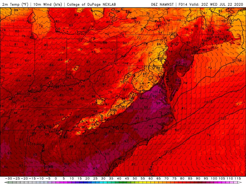
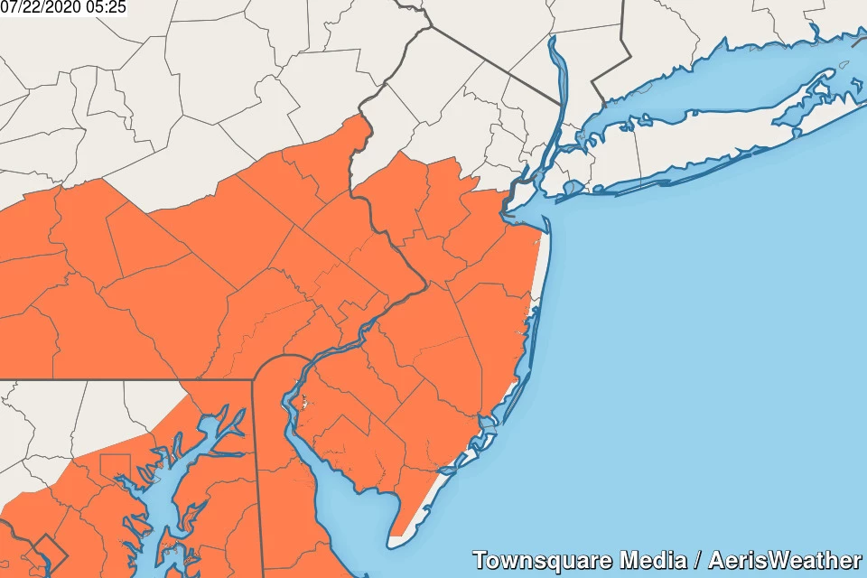
A Heat Advisory has been issued for inland central and southern New Jersey from 11 a.m. to 8 p.m. Wednesday. You know the drill — dress for the heat, take frequent breaks (in air conditioning, if possible), and stay extra hydrated.
Issue number two is the potential for some powerful thunderstorms. Our atmosphere will be very unstable, and conducive to strong to severe storms with damaging winds and flooding rain. An isolated tornado also can't be ruled out, especially in northern New Jersey (where the shear profile will be more conducive to a twisting storm).
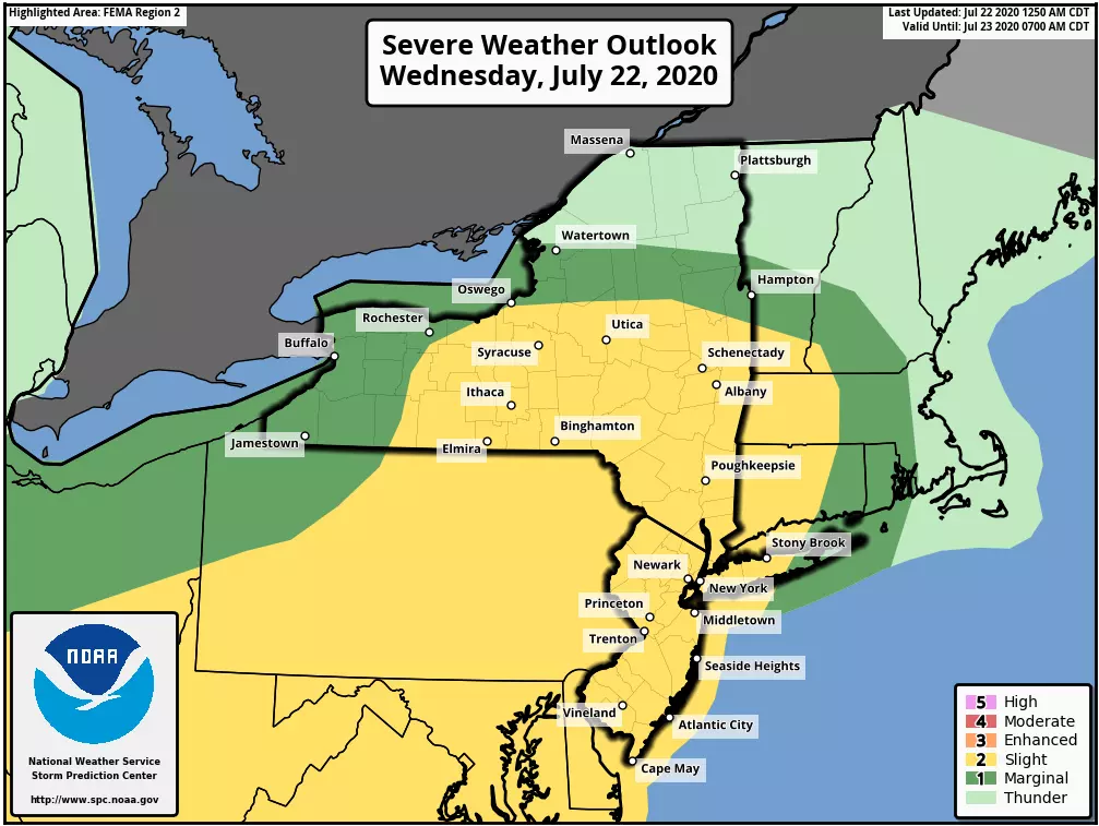
In terms of timing, one or two models paint an isolated popup thunderstorm over New Jersey around 3 or 4 p.m. Wednesday afternoon. (There's a good chance it will be too hot for storms to form and grow — our atmosphere will be capped.) The better chance for widespread storms will be Wednesday evening, moving from west to east between about 6 and 10 p.m. The storm impacts will be brief, but pretty nasty.
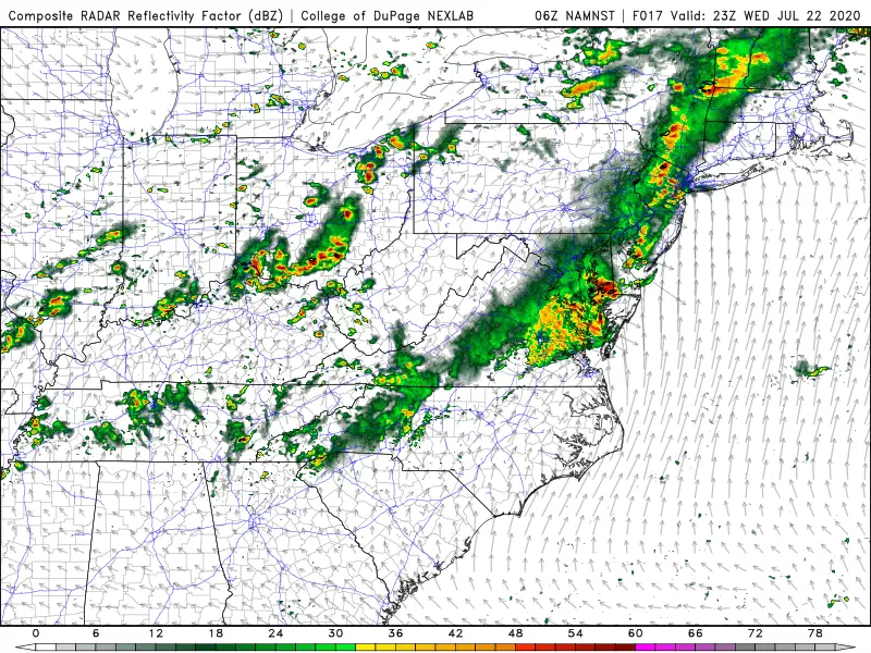
Rain should end by around Midnight. The rest of the overnight will be calm, although muggy, with low temperatures only falling into the mid 70s.
Thursday
Both temperatures and dew points should dial back enough to pull us out of "dangerous heat" territory. Still, we're facing high temperatures in the upper 80s to around 90. The heat index may approach 100. Skies will be partly to mostly cloudy. And another round of late-day thunderstorms is likely. Once again, the evening hours look to bring the best chance of storms.
Friday
I don't think model guidance has a great grasp of what's going to happen Friday. A cold front will introduce a chance of showers, and some models paint a generally wet and unsettled day. As a result, Friday could be our coolest day of the week, with highs "only" between 85 and 90 degrees. If there's any day where NJ might miss out on 90+, this would be it.
Saturday
The weekend is looking summery, as temperatures heat up again. But there's a lot to like here. Saturday will be the sunnier day of the weekend, with highs near 90.
Sunday
More clouds, more humid, and hotter. No substantial rain threat, at least. Highs pop into the lower-mid 90s.
The Extended Forecast
It looks like extreme heat ramps up again for early next week, with widespread 90s on thermometers. There will be a chance of showers and thunderstorms late Monday into Tuesday.
Dan Zarrow is Chief Meteorologist for Townsquare Media New Jersey. Follow him on Facebook or Twitter for the latest forecast and realtime weather updates.
More From 105.7 The Hawk