Thursday NJ weather: Falling raindrops, snowflakes, and temperatures
The Bottom Line
A big transition is underway. After glorious sunshine and 50-degree weather on Wednesday, arctic air is once again knocking on New Jersey's door.
A quick burst of rain and snow Thursday morning will be accompanied by tumbling temperatures. Cold air is going to be a common theme in this forecast, with temperatures at or below normal for the foreseeable future. (In fact, most of the state will probably be stuck betlow freezing for almost 72 consecutive hours, from Thursday morning to Sunday morning.)
A precarious coastal storm on Saturday looks like a glancing blow, at the most. Things look pretty quiet through next week.
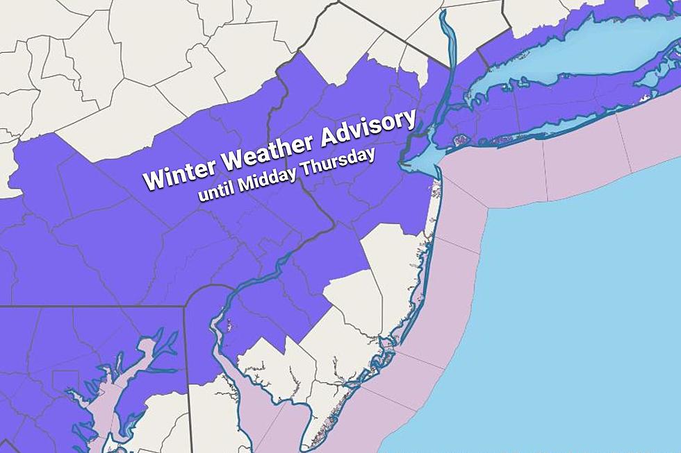
Thursday
The progression of our cold front - with its colder temperatures and tricky rain-to-snow changeover - is happening slower than I expected. As of this writing (6:30 a.m.), just plain rain is falling across the state. Temperatures are starting the day in the (relatively mild) 30s and even 40s.
But the cooldown is underway. The big turning point will probably be around 8 a.m. as temperatures dip below the magical freezing mark. Whoever is under the heaviest band of precipitation at that time will see a quick inch or two of snow accumulation. (At the moment, the heaviest rain is lined up along and just southeast of the NJ Turnpike corridor.)
As we've discussed ad nauseum for days, this is not a "major" winter storm. Cold fronts generally don't drop big snow, as the arrival of dry air shuts down precipitation. Wet ground is not conducive to big snow accumulation either. The concern is that untreated roads could become slippery very quickly, and visibility could drop sharply. And an inch or two of snow isn't really plowable, so road crews have a particular challenge ahead of them.
A Winter Weather Advisory continues until midday (11 a.m. or 1 p.m., depending on your county) cautioning of treacherous travel due to snow and ice.

The steadiest, most widespread snowfall will occur between about 8 a.m. and 1 p.m. Lingering snow showers are possible through the afternoon, especially along the southern coast.
Of course, the other big weather headline Thursday is the return of frigid air. Temperatures will fall from the 30s into the 20s Thursday afternoon.
As skies clear Thursday night, thermometers will drop even more. Lows will end up in the teens. And any little breeze will push the wind chill closer and closer to zero. Back to bundling up.
Friday
Another "arctic chill" kind of day. Highs will only reach the mid 20s at best. The entire state will be stuck below freezing all day. Chilly sunshine should dominate for most of the day, filtering through clouds later on.
Saturday
Some forecasters are still freaking out about a potential coastal storm early Saturday. I'm really not - model guidance has shifted far enough east that a "hit" on NJ seems unlikely.
I will hold on to the chance of light snow along the Jersey Shore early Saturday morning. Maybe even some light accumulations. But that's it.
The rest of Saturday should feature increasing sunshine and the continuation of cold temperatures. Highs will only reach about 30 degrees, give or take.
Sunday
As winds shift from northerly to a west-southwest direction, temperatures will warm slightly to more seasonable levels. Look for highs in the upper 30s, with periods of sun and clouds. It looks like a dry finish to the weekend.
The Extended Forecast
Temperatures will ride a little roller coaster through the rest of January, but models show generally quiet weather. (Cold air is dry air, and a big dome of high pressure keeps any storm track far far away.)
Upper 30s Monday. Mid 40s Tuesday. Mid 30s Wednesday.
Be safe out there Thursday morning.
Dan Zarrow is Chief Meteorologist for Townsquare Media New Jersey. Follow him on Facebook or Twitter for the latest forecast and realtime weather updates.
Inside ISLAND Waterpark, coming soon to Atlantic City
Gallery Credit: Joe Votruba
NJ's Route 22 circa 1984 — Do you recognize these businesses?
Gallery Credit: Joe Votruba
More From 105.7 The Hawk


