Stormy and sloppy, but not really snowy: NJ nor’easter update
UPDATE... This article is outdated...
For the latest winter storm forecast information, please refer to my newest weather blog post.
The Bottom Line
A significant coastal storm system — a nor'easter — is set to impact New Jersey from Thursday through Friday. But it has become clear the track of the storm is really not a snowy one for us.
Yes, there are some wintry, icy concerns. But for most of New Jersey, heavy rain will be the predominant weather type here. (With some wind and coastal flooding too.)

Before the Storm
Wednesday will be chilly, but quiet. We are starting off with temperatures mainly in the 20s — it is ever so slightly warmer than Tuesday, but definitely still "bundle up" weather.
Especially with a chilly breeze that will be especially prevalent through the first half of Wednesday. The high temperature should reach about 40 degrees Wednesday afternoon. But the wind chill (or "feels like" or "apparent" temperature) will be closer to 30.
Skies will be bright, with abundant sunshine through most of the day. Some clouds will start to fill in around the middle of the afternoon.
I think it's fair to also call Wednesday night's weather quiet. Under increasing clouds, it will be cold. Low temps should bottom out in the upper 20s to around 30. (Keep those sub-freezing temperatures in mind — they're important for the next piece of the weather puzzle.)
Nor'easter Timeline
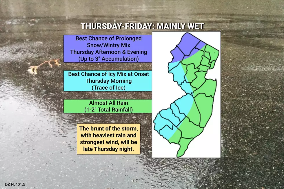
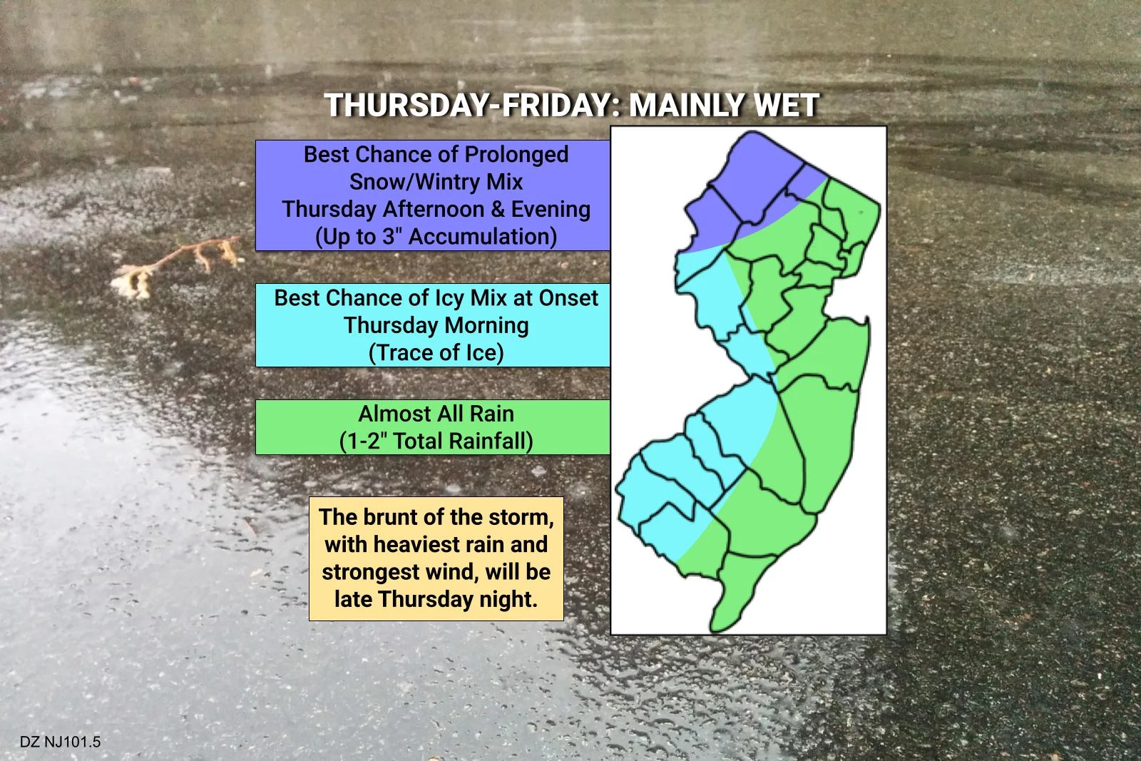
—Initial band of light to moderate precipitation will push into southwestern New Jersey just after daybreak Thursday. Over the first few hours of the storm Thursday morning, rain may mix with snow and sleet, making for potentially slippery spots during the AM commute. (Especially along the western edge of the state.)
—Rain will spread into northeastern New Jersey by midday Thursday. Periods of light to moderate rain will continue to affect the state through Thursday afternoon.
—Temperatures may be cold enough during the daytime hours Thursday for a prolonged period of snow and wintry mix in far northwestern New Jersey. Light accumulations and slick travel are possible.
—The brunt of the storm, with the heaviest rain and the strongest winds, will arrive Thursday night. Everyone in the state gets soaked and windswept — definitely a period of inclement weather.
—Showers are going to linger for a bit on Friday, through at least midday. So it won't really be a pleasant day. Clearing skies will take over Friday night.
Impact #1: Icy Mix
We will have to watch conditions during Thursday morning's commute for icy patches. The first band of precipitation may arrive before temperatures start to warm for the day. And it wouldn't take much icy mix to make travel slick. The best chance for such a slippery situation will be the western edge of NJ.
A Winter Weather Advisory has been issued for Thursday 5 a.m. to Noon for Salem, Gloucester, Camden, and northwestern Burlington counties.
Impact #2: Snow Accumulation
While models showed North Jersey getting buried just a few days ago, it looks like warm air is going to win the day after all.
As I mentioned above, there is a good chance for a prolonged period of snow and wintry mix in NW NJ. We're talking about the usual area, north of I-78 and west of I-287.
My estimates put potential snow accumulations at or below 3 inches. (And even that may be an overestimate.) I suppose there is a chance for a last-minute "wiggle" in storm track and forecast temperatures, leaning us toward a snowier forecast. Again, the evolution of this will be critical to watch as the storm arrives.
A Winter Weather Advisory is posted for Sussex and Warren counties from Thursday Noon through Midnight.
Impact #3: Heavy Rain
For most of the state, we just get soaked. Total rainfall will reach about 1 to 2 inches. Quite healthy for December. There could be some ponding and visibility issues during downpours. But I don't think widespread, dramatic flash flooding is going to be a problem.
Impact #4: Wind
Easterly wind gusts will reach about 30 mph for most of the state, and 40 mph along the Jersey Shore. That will potentially reduce visibility even further, bring down tree branches, and cause sporadic power outages.
Impact #5: Coastal Flooding
A strong east, on-shore wind? Yes, that means we have to talk about storm surge and coastal flooding too.
During both high tide cycles on Friday, a foot or two of surge will cause widespread minor flooding of tidal waterways along the Jersey Shore. That equates to "the usual spots". It is worth mentioning that some tidal guidance pushes very close to moderate flood stage in spots.
After the Storm
Skies will clear Friday night, and then we'll be under the influence of high pressure, fair weather, and cold temperatures into next week.
Saturday should be mostly to partly sunny, with light winds and highs around 40 to 45 degrees. Not a bad December day.
Sunday will be the colder day of the weekend, with high temps again scaling back to around 40. But again staying dry.
The final days of autumn next week look to get even colder, with highs potentially stuck in the 30s for Sunday, Monday, and Tuesday.
Our next threat for a storm system would be in the middle to late part of next week. Almost a week break — I'll take it.
Dan Zarrow is Chief Meteorologist for Townsquare Media New Jersey. Follow him on Facebook or Twitter for the latest forecast and realtime weather updates.
Let it snow: 12 things to know about winter forecasting in NJ
Gallery Credit: Dan Zarrow
The 99 top paying jobs in New Jersey
More From 105.7 The Hawk


