
NJ’s first Heat Advisory of the year: Not just hot Wednesday, but humid too
Most high temperatures across New Jersey on Tuesday hit 85 to 90 degrees.
Most forecast high temperatures across New Jersey for Wednesday are in the 85 to 90 degree range.
But the day will have a very different feel, thanks to high humidity making conditions more uncomfortable and stifling.
We're starting off this Wednesday morning with temperatures ranging from 60 (north) to 70 (southern half). Generally pretty sticky, feeling like a summer morning. As the sun comes up, thermometers will quickly race toward 85 to 90 degrees.
Of course, when there's heat and humidity in the forecast, we have to talk about the "heat index" — our summertime "feels like" or "apparent" temperature, which factors in the temperature and humidity (technically, dew point) to give an estimation of how the combination will impact human health. Wednesday afternoon's heat index is expected to push into the lower to mid 90s — possibly as high as 96 or 97 degrees. Steamy!
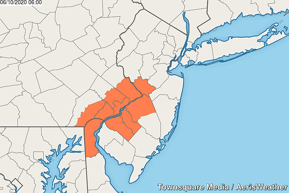
The hottest part of the state will be to the southwest, around the Philadelphia metro area. Our first Heat Advisory of the season has been issued for Mercer, NW Burlington, Camden, and Gloucester counties during the heat of the day, from 1 p.m. to 7 p.m. This is right on the bottom edge of dangerous heat, so make sure you're dressing for the weather and staying extra-hydrated.
On the flip side, the coolest part of the state will be the Jersey Shore. By far! This will be one of those days with a 15 to 20 degree difference between the immediate coast and just a few miles inland. (Drive along I-195, Rt. 37, Rt. 72 or the Atlantic City Expressway to experience "sea breeze science" in action!)
Even though this will be our 5th beautiful "beach day" in a row, I will warn you that a Moderate Risk of dangerous rip currents and rough surf has been posted for New Jersey's coastline Wednesday.
A storm system over the Great Lakes (the remnants of Cristobal) will spit some rain in our direction late-day Wednesday. So a shower or thunderstorm is possible from late afternoon into Wednesday evening, but those raindrops really look to be limited to NW NJ only.
For the rest of the state, it will be mostly cloudy and muggy overnight. Low temperatures will only fall into the lower 70s.
It looks like all of New Jersey will get wet at some point on Thursday, as a cold front slides from northwest to southeast across the state. Timing this thing has been a real pain to pinpoint. But I'm zeroing in on the Thursday midday to afternoon hours as the best chance for a period of rain. Thunder and lightning will be possible, along with some brief downpour action. But the threat for severe weather (wind, hail, tornado) will be relatively low, thanks to limited sunshine and cooler temperatures.
Thursday will definitely feel steamy too, as high humidity continues. But mostly cloudy to overcast skies should hold temperatures to about 80 degrees.
On Friday, we should flip back to great weather as humidity drops and sunshine emerges. (There may be some extra clouds along the coast, as that aforementioned cold front stalls just to our southeast.) The day looks dry and delightful, with highs back in the just-above-normal lower 80s.
The forecast for the weekend is shaping up, and it's going to feature mixed news. Saturday should be a continuation of Friday's pleasant weather, with mostly to partly sunny skies and highs in the lower 80s. For now, I can't rule out a stray late-day shower.
Sunday, however, will turn cooler and wetter as a stagnant area of low pressure sets up shop just off the coast. That will drive a cooling east-southeast wind our way, pushing high temps down into the 70s. And it will also spark scattered rain and clouds through much of Sunday afternoon and Monday.
Hopefully that "stuck" storm system kicks out to sea on Tuesday, allowing for a return to pleasant, warm weather through midweek.
More From 105.7 The Hawk