
NJ weekend weather: 5 things to know about Saturday’s big transition
91° Tuesday. 95° Wednesday. 98° Thursday. 99° Friday. It's been a scorching hot week across New Jersey. And when humidity is factored in, we had three days in a row with the heat index popping above 110°. Yuck!
Sweet relief is in sight as we dive into the weekend. Saturday is our big transition day, as we progress from humidity to thunderstorms to a much cooler, drier air mass. It's going to be a slow process. And while there will be pockets of pleasant (although sweaty) "beach weather" early on Saturday, you will have to watch out for raindrops and rumbles of thunder.
Here's how the forecast timeline is shaping up...
1.) Saturday Morning: Still Humid and Very Warm
The heat warnings and advisories are already gone, as we will stay out of the "danger zone" on Saturday. It's still going to be a steamy, sweaty, soupy start to the day.
Morning temperatures are once again primarily in the 70s. And most high temperatures will reach the upper 80s to 90 degrees Saturday afternoon. Still above normal for mid August, but at least it's more reasonable than near-record upper 90s.
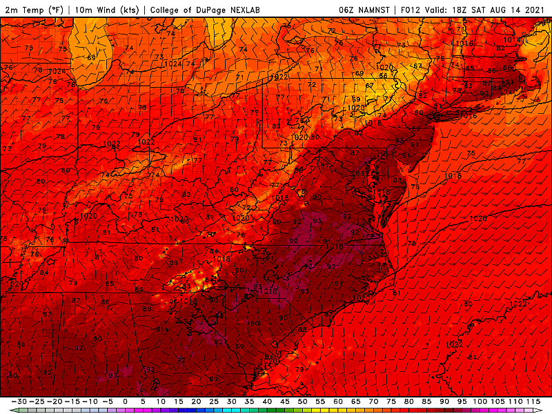
We've talked so much about the heat index lately - that's the "feels like" or "apparent" temperature that serves as our measuring stick for "dangerous" versus "run of the mill" heat. I expect Saturday's heat index to peak in the mid to upper 90s. Staying out of the 100s is already an improvement.
I'm not sure how prominent the sea breeze will be in keeping temperatures down at Jersey Shore beaches, thanks to diminishing sunshine and a westerly (land) breeze around 15+ mph. Best chance for cooler temps would be on barrier islands, surrounded by (relatively) cooler water.
2.) Saturday Midday-Afternoon: Scattered Showers & Thunderstorms
The atmospheric lift associated with our approaching cold front will be enough to spark scattered showers and thunderstorms. Model solutions for rain chances have ranged from minimal to pockets of heavy rain - unfortunately that limits my confidence in this forecast, but I'll try my best to piece together the timeline and impacts.
As of this writing (7 a.m.), we already have some spotty rain moving through North Jersey, mainly along and north of Interstate 80. That will exit soon enough and the morning hours will generally be dry, with substantial peeks of sunshine.
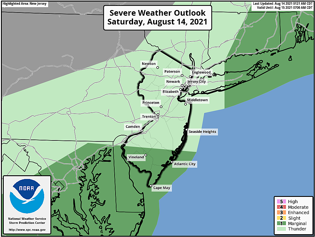
Our "main event" will be between the hours of Noon and Midnight. So scattered showers and thunderstorms may develop starting around midday, through the afternoon and evening. If I had to pin down one area of concern, it would be the southern half of the state around late afternoon and early evening. That will be the best opportunity for pockets of torrential rain and an isolated strong storm cell. (Severe weather parameters are limited, but enough to warrant a mention.)
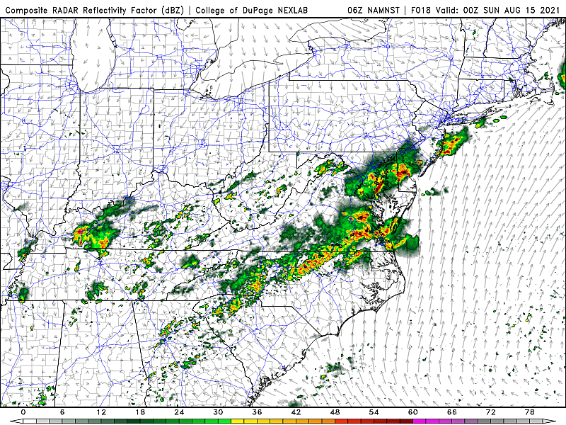
Any thunderstorms and rain will be pushed out Saturday evening as our new air mass arrives.
Bottom line: A few showers and thunderstorms will pass through New Jersey on Saturday, although not everyone will see a storm. While the morning looks dry, raindrops and rumbles of thunder could put a quick end to outdoor plans Saturday afternoon and evening. If you hear thunder, see lightning, see the sky darkening up, or feel raindrops, it's time to head inside.

3.) Saturday Evening: Cooler, Drier Air
Ahh, the sweet relief we've been excited about all week. Dew points (and therefore humidity levels) will plummet from the 70s to the 50s starting around late afternoon in northwestern New Jersey. It may take a while for that drier air to reach the southern coast - probably closer to Midnight. But the air will almost immediately feel different - thinner, refreshing, and definitely more comfortable.
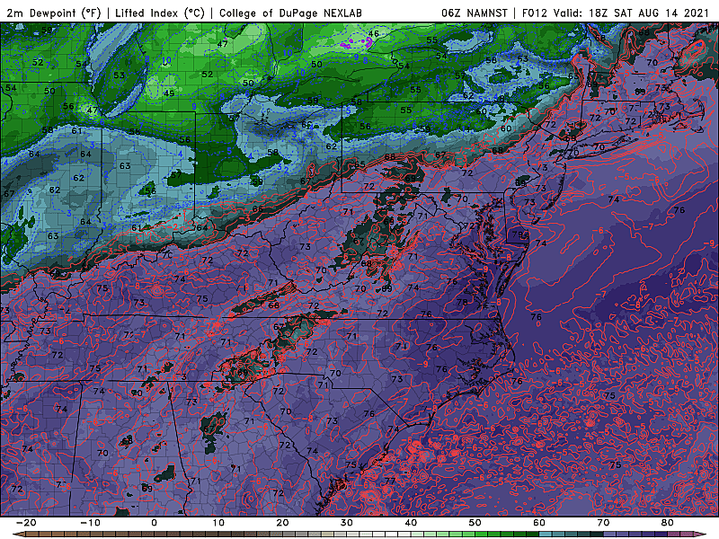
By Sunday morning, temperatures will bottom out in the seasonable 60s across the state. There could even be some 50s on thermometers to the north and west.
4.) Sunday: Refreshing and Comfortable
In the three weeks prior to our latest heat wave, we had several streaks of really pleasant, bone-dry weather. And I'm excited to say such sensational conditions return for the second half of the weekend!
Sunday's high temperatures will come down to about 80 to 85 degrees. That's actually a hair below normal for mid-August. Increasing sunshine, light winds, and a dry forecast will make for a very nice summer day.
We had been watching the chance for a few showers in far southern New Jersey, as the aforementioned cold front stalls over the mid-Atlantic. Latest models have backed off that idea, keeping raindrops closer to Delaware and Maryland. But I will say it's not impossible for some rain activity in the vicinity of Salem, Cumberland, and Cape May counties Sunday morning.
5.) Things to Watch for Next Week
Monday looks just as good as Sunday, with highs again in the lower 80s. Tuesday will get slightly stickier, but temperatures will stay at or below normal for the foreseeable future.
One item to watch is the progression of Tropical Depression Fred, expected to strengthen into a tropical storm in the Gulf of Mexico before making landfall around the Floribama Shore. Fred's track has trended significantly westward.

Tropical moisture from Fred will spread toward New Jersey starting Tuesday afternoon. That's the culprit for the midweek rise in humidity. And our weather could turn unsettled, with bands of spotty showers possible on a daily basis. To be clear, Fred is not and will not be a "strong" storm - I highly doubt we'll see anything more than just rain from its residual moisture.
Even more concerning is newly named Tropical Storm Grace, centered about 2,000 miles southeast of New Jersey.

Grace's latitude and that track is conducive to an East Coast landfall. Exactly what that means - in terms of the rain, wind, surge threat - is completely up in the air. Grace would not be anywhere near New Jersey for at least 10 days - the middle of next next week. But we'll be watching and updating in the meantime.
Enjoy the rest of your weekend - the big cooldown is going to be awesome!
Dan Zarrow is Chief Meteorologist for Townsquare Media New Jersey. Follow him on Facebook or Twitter for the latest forecast and realtime weather updates.
Seven boardwalk games and how they can be stacked against you
Gallery Credit: Jeff Deminski
UP NEXT:Try these tips to save on energy bills
More From 105.7 The Hawk


