
NJ weather: Cold air is back, now let’s get serious about weekend snow storm
UPDATE... This article is outdated...
For the latest winter storm forecast information, please refer to my newest weather blog post.
The Bottom Line
The snow storm hype machine is fully fired up now, as we continue to watch the potential for a powerful coastal storm (nor'easter) for the start of the upcoming weekend. And I fully admit some of that hype is justified, as the "worst-case scenario" would involve double-digit snowfall burying most of New Jersey with blizzard conditions.
However, that is absolutely not the only scenario still in play. There are still significant differences among forecast model solutions regarding the track, size, and strength of the storm. Will the center of low pressure track close enough to the coast and phase (explode) at the right moment? Or will it be a "coast kisser" storm, with some impacts for New Jersey, but not a blockbuster "bread and milk" kind of event.
Confidence is low, uncertainty is high. So it's still too early to put definitive numbers on this forecast — they are guaranteed to be wrong at this point. I do want to paint a general picture of the timeline and potential impacts, so you can plan accordingly. (At this point, I'd keep your Friday night to Saturday plans as flexible as possible, but don't cancel anything yet.) I expect to be able to fill in more details within the next 24 hours.

Before the Storm: Quiet and Cold
The first ingredient of any good snow storm is cold air. And for the fourth time this month, we're entering a stretch of unseasonably frigid weather.
Temperatures on this Wednesday morning have fallen to the teens and 20s across New Jersey. And we'll be stuck in the freezer all day, with highs only averaging upper 20s. (We might hit 30+ in South Jersey only.)
Wind speeds will come close to what I'd call "breezy". Both our weather and air will be very dry. At least skies will stay bright and sunny.
Wednesday night will probably be one of the coldest nights of the season so far. (I doubt it will be the coldest — that honor belongs to the morning of 1/16, which had widespread single digits across the state.) By Thursday morning, we'll average mid teens. The coldest corners of the state will almost certainly end up in the single digits. Skies will be clear and winds will be light overnight.
Weekend Snow Storm: What We Know
—There will be a storm... It's really the first box to tick when forecasting a winter storm, as these things sometimes completely "fizzle" as time goes on. There will be a powerful coastal storm over the Atlantic late this week — it's just a matter of track and timing.
—An "appetizer" piece of energy is an important forecast factor... Snow showers are possible as early as Friday morning. I've seen some model runs even hint at a coating to an inch of accumulation in spots during the day. That's before the "coastal storm" piece of the puzzle even approaches. It looks like that impulse will work in tandem with the coastal low, rather than push it off the coast. So I'm calling it the "appetizer" to the potential "main course" steadier, heavier snow.
—The storm will ramp up Friday night... The timing of the first half of the storm seems set. The outer band of the storm system should push into New Jersey Friday evening — let's say between about 6 p.m. and Midnight. Hopefully missing the PM rush hour (although see my note about earlier "appetizer" snow showers). And then peak snowfall, with fastest accumulation, lowest visibility, and poorest travel conditions should come early Saturday morning — let's say between about Midnight and 6 a.m. The "brunt" may end up drifting later, into the daylight hours — just something to keep in mind.
—It will produce almost all snow... It's cold. And it's going to stay cold for the duration of the storm. That means the risk for mixing and icing will be very limited. (Immediate coastal communities could see some ice pellets and/or raindrops at some point, especially if the storm's warmer center wiggles closer to the coast.) Snow will accumulate immediately on cold, untreated surfaces.
—Wind could be an issue too... A strong storm carries a tight pressure gradient, and that means the wind will kick up. This is especially a concern for Saturday morning. Wind may not only knock out power for some, but also reduce visibility dramatically within snow bands. Blizzard or near-blizzard conditions can't be ruled out.
—At least some travel disruptions seem likely... With a "complete miss / out-to-sea" scenario seemingly off the table, I am becoming increasing confident that part of New Jersey (i.e. the coast) will see accumulating snow and inclement weather. Probably enough to be shovelable and/or plowable. And probably enough to cause problems for travelers of all modes. The difficulty in this forecast is now a matter of geography and magnitude.
Weekend Snow Storm: What We Don't Know
—The storm track is precarious... At the moment, I estimate the entire suite of forecast models has a spread of about 150 miles in the location of the nor'easter center as of Saturday morning. (In case you're wondering, the Euro and Canadian are the snow bombs, while the GFS and UKMET show more meager snowfall over New Jersey.) We need run-to-run and model-to-model consistency before locking down a more specific forecast with specific numbers.
—The end time is difficult to pinpoint... There are also big differences surrounding when the flakes will stop flying. Unsurprisingly, the snowier solutions (looking at you, Euro) keep snow bands over New Jersey into Saturday afternoon. I don't think there's any good reason for the storm lingering near our coastline for so long, but the chance is still alive.
—Exact snow impacts depend entirely on those two points... That's really what it comes down to: Who gets how much snow and when. If the storm tracks along the "sweet spot", snowfall totals could range from 4 inches in NW NJ to a crippling 2 feet along the coast. But if it wiggles east, the "coast kisser" track, it would be more like 0 inches in NW NJ to 4-ish inches along the coast. Big range. And if I went on social media promoting the idea of a "0 to 24 inch snowfall" forecast, I'd be the target of much laughter and anger. The best answer is probably right in the middle But I'm very hesitant to put out specific numbers yet, because it's practically guaranteed they would be wrong.
—Exact wind impacts depend entirely on those two points... The closer the center of the storm gets to the coast, the stronger the wind will blow. We're talking about the difference between 20 mph (best-case) and 50 mph (worst-case) gusts.
—Exact coastal impacts depend entirely on those two points... Storm surge and tidal flooding are largely dependent on the speed and magnitude of the wind. And, as I mentioned, that depends on the exact location and track of the storm. We start getting a picture of coastal flooding magnitude and geography about 48 to 72 hours beforehand. So that's coming up soon.
Weekend Snow Storm: Putting It Together
If I had to write a specific forecast for the storm right now, it would look something like this:
A few snow showers are possible during the day Friday, with light accumulations possible. Then the chance for steadier, heavier snow ramps up Friday evening, especially along the coast. Saturday morning will remain snowy and windy. Then clearing skies and bitterly cold through the rest of the weekend.
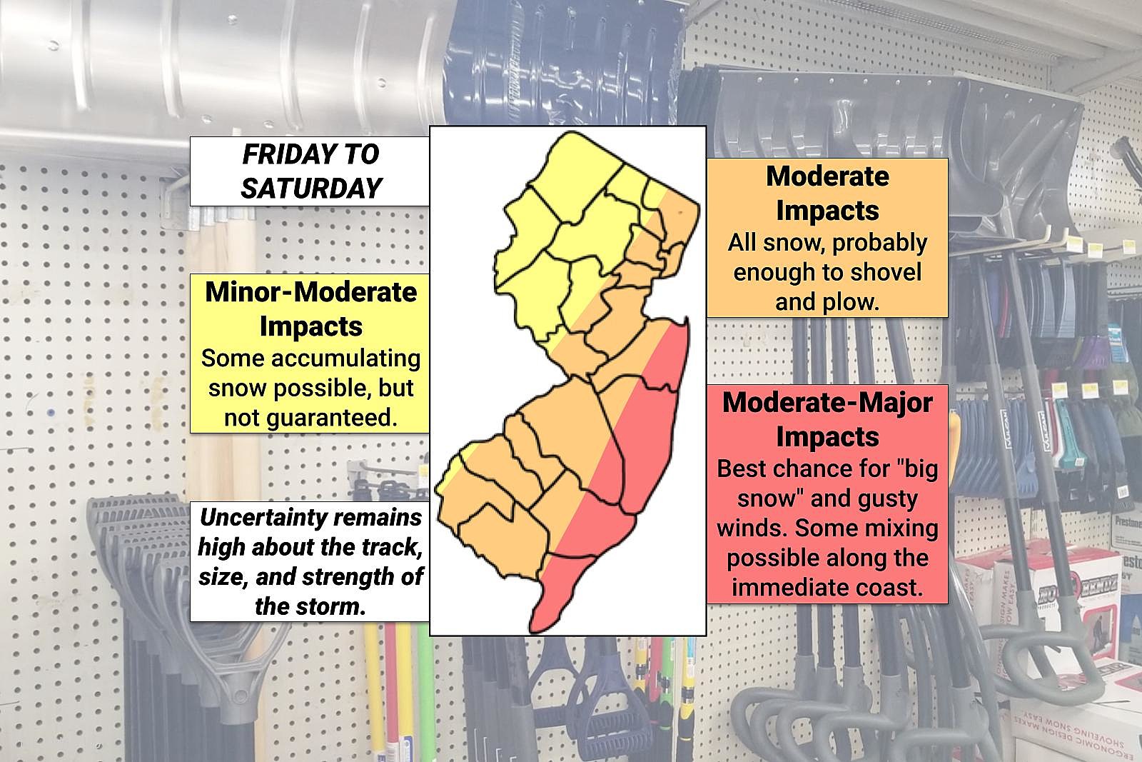
Snow accumulation will range from 0-3" in northwestern New Jersey, 3-6" on either side of the NJ Turnpike corridor, and 6-12+" for most of the Jersey Shore. (FYI, that corresponds with the yellow, orange, and red areas on my impacts map above.) Wind gusts of 40+ mph are possible. Minor to moderate coastal flooding may occur at high tide as well.
After the Storm: Bitter Cold
As the storm exits to the northeast, another pocket of very cold air will be concurrently dragged into New Jersey from the northwest. I do not expect temperatures to warm beyond the 20s on Saturday nor on Sunday.
And it's not like the wind will die down immediately as the storm departs. So I am particularly concerned about the wind chill Sunday morning, which may dip below zero. That is when we have to start ringing alarm bells for "dangerous" cold.
Turning the calendar page from January to February next week, temperatures should moderate a bit. The exact numbers will depend largely on snow cover and post-storm dynamics.
I may or may not push out a weather blog update Wednesday afternoon. No matter what, I'll be back Thursday morning with the latest, likely around the 7 a.m. hour. Of course, you can turn on your radio or pop open our mobile app for the latest forecast any time.
Dan Zarrow is Chief Meteorologist for Townsquare Media New Jersey. Follow him on Facebook or Twitter for the latest forecast and realtime weather updates.
Cough, cough: NJ's favorite lost voice and sore throat remedies
Gallery Credit: Dan Zarrow
BEEP BEEP BEEP: These are the 13 types of Wireless Emergency Alerts auto-pushed to your phone
Gallery Credit: Dan Zarrow
More From 105.7 The Hawk


