
NJ weather: 6 things to know about our Christmas wind and rain storm
A strong cold front will lead to some tumultuous weather conditions here in New Jersey, especially between Christmas Eve to Christmas Day. It'll be far some a "silent" night, as our weather turns quite nasty and noisy for a time. Damaging winds may cause power outages, heavy rain may cause flooding, and a flash freeze may lead to icing.
But don't worry too much about all the dramatic weather, kiddies — Santa Claus is well-prepared for any weather eventuality.
1.) Thursday Daytime Looks OK
Christmas Eve in New Jersey will start cloudy, breezy, and warm. Temperatures will steadily rise through the 50s as the day goes on, topping out around 60 degrees late-day. A few rain showers are possible during the day, especially along the western edge of the state. The wind won't start really kicking up until mid-afternoon. And the heavy rain won't come until later at night.
2.) WIND... High Wind Warning & Wind Advisory
I think the number one concern from this stormy setup will be the wind, which may lead to downed trees and widespread power outages. Severe wind is bad news any day of the year, but especially on a major holiday like Christmas.
The strongest wind is expected to blow through New Jersey between about 5 p.m. Thursday and 5 a.m. Friday. Southeasterly gusts will probably hit 40+ mph in every county in the state. 60+ mph gusts are possible along the Jersey Shore.
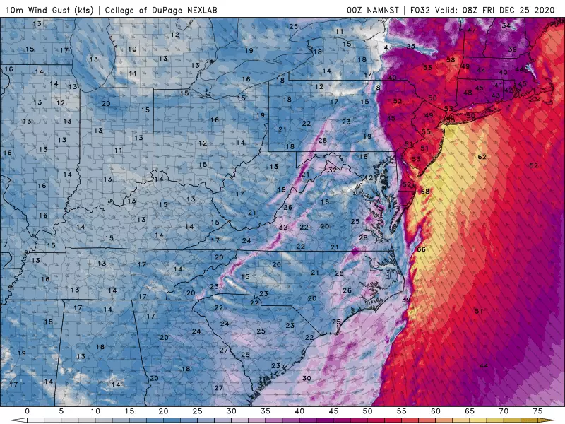
A High Wind Warning has been issued from Thursday evening through Friday morning for Hudson, Monmouth, Ocean, southeastern Burlington, Atlantic, and Cape May counties. That's a pretty serious one.
A less severe Wind Advisory covers the rest of the state.
3.) RAIN... Flood Watch
We are going to get soaked. Flooding rain is bad news any day of the year, but especially on a major holiday like Christmas.
I'd estimate the heaviest rain will sweep through New Jersey between 7 p.m. Thursday and 9 a.m. Friday, with lingering light rain on either side of that window. Rainfall totals will likely end up between 1 and 2 inches across the state, with 3+ inch rainfall possible in northwestern New Jersey. That could lead to visibility, traction, ponding, and flooding issues. Thunder and lightning is possible too.
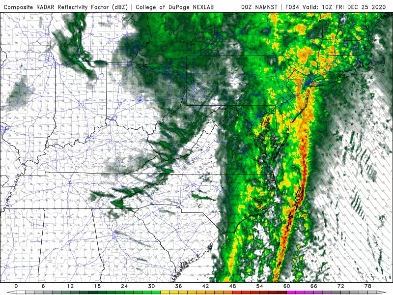
A Flood Watch is posted from Thursday evening through Friday morning for Sussex, Warren, Morris, Hunterdon, Somerset, Middlesex, and Mercer counties.
4.) COLD... The Big Cooldown
Behind the front on Friday, temperatures will start to nosedive, as cold air arrives on a brisk westerly wind. While we'll still be close to 60 degrees (in the rain) in the early morning hours, the thermometer will approach 40 by lunchtime and then 30 by dinnertime. Overnight low temperatures will probably reach the mid teens to mid 20s across the state, with the wind chill even colder. Get ready to bundle up!

One big concern with the impending cold is the potential for a flash freeze. There are going to be substantial puddles and wet spots after the Christmas morning rain. And because temperatures are set to drop so fast, those puddles may freeze over before they can evaporate. That may lead to a perilously slippery situation Friday night through Saturday morning. So watch your step, and use extra caution on the roads.
5.) SNOW... White Christmas?
For a week, we've been regularly examining the possibility of snowflakes falling from the sky on Christmas. (And how magical and festive that would be!) I think we still have a shot, albeit a limited one.
Technically, the official definition of a White Christmas requires an inch of snow on the ground, on either December 24 or 25. Some places in the Garden State will actually hit that criteria by default, thanks to existing snow cover from last week's nor'easter. However, expect substantial snow melt on Christmas Eve due to the warmth and the rain.
I think there are two opportunities for falling snowflakes over the holiday:
1.) If temperatures start to drop before the rain wraps up around mid-morning on Christmas Day, there could be a period of light snow.
2.) A few isolated snow showers or flurries are possible in the afternoon and early evening too. (This one is probably the more likely scenario, FYI.)

Again, don't expect much. Especially since models have backed off any solid snowfall solution. Plus, the ground will be too warm and wet for anything to stick, so there won't be any accumulation snow-related travel difficulties.
6.) The Rest of the Holiday Weekend
Quiet, but cold. Despite sunny, blue skies on Saturday, high temperatures will only reach about the freezing mark, in the lower 30s. (Happy Boxing Day!) On Sunday, temps should moderate slightly to the upper 30s.
Some rain and snow showers will be possible on Monday. The next storm system that bears watching will be around New Year's Eve, next Thursday.
Parting Thoughts
Whether your Christmas is warm, wet, windy, or (somewhat) white... I truly hope it is merry and bright, healthy and safe.
The weather blog will take a hiatus through the holiday season, as I take some much-needed vacation time. If any big weather situation develops, I will jump back in, of course. Otherwise, I'll "see" you next on Monday, January 4th.
Dan Zarrow is Chief Meteorologist for Townsquare Media New Jersey. Follow him on Facebook or Twitter for the latest forecast and realtime weather updates.
More From 105.7 The Hawk

