Jersey Shore Report for Thursday, December 17, 2020
Advisories
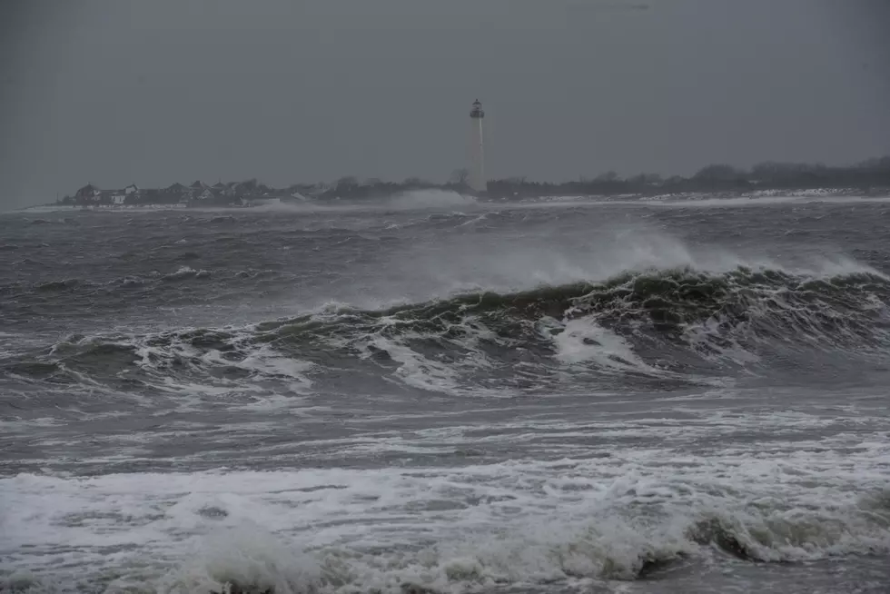
--Coastal Flood Warning and Advisory for the Jersey Shore. Moderate flooding expected during Thursday morning's high tide cycle, with up to 2 feet of surge and water inundation.
At the Shore
Current conditions and forecast as of Thursday morning
| Air Temperature | 33° - 41° |
|---|---|
| Winds | From the North 19 - 37 mph (Gust 48 mph) 17 - 32 knots (Gust 42 knots) |
| Waves | 5 - 12 feet |
| Rip Current Risk | High |
| Ocean Temperature | 45° - 48° (Normal 42° - 44°) |
| Sunrise/Sunset | 7:12am - 4:39pm |
| UV Index | 1 (Low) |
Tide Times
| SANDY HOOK Sandy Hook Bay | High Thu 9:33a | Low Thu 4:04p | High Thu 10:07p | Low Fri 4:09a | |
| LONG BRANCH Atlantic Ocean | High Thu 9:07a | Low Thu 3:28p | High Thu 9:41p | Low Fri 3:33a | |
| MANASQUAN INLET Atlantic Ocean | High Thu 9:21a | Low Thu 3:40p | High Thu 9:55p | Low Fri 3:45a | |
| SEASIDE HEIGHTS Atlantic Ocean | High Thu 9:03a | Low Thu 3:32p | High Thu 9:37p | Low Fri 3:37a | |
| SEASIDE PARK Barnegat Bay | Low Thu 7:26a | High Thu 1:13p | Low Thu 8:09p | High Fri 1:47a | |
| BARNEGAT INLET Barnegat Bay | High Thu 9:21a | Low Thu 4:05p | High Thu 9:54p | Low Fri 4:02a | |
| MANAHAWKIN BRIDGE Manahawkin Bay | Low Thu 7:00a | High Thu 12:20p | Low Thu 7:43p | High Fri 12:54a | |
| LITTLE EGG INLET Great Bay | High Thu 10:06a | Low Thu 4:33p | High Thu 10:37p | Low Fri 4:27a | |
| ATLANTIC CITY Atlantic Ocean | High Thu 9:10a | Low Thu 3:42p | High Thu 9:41p | Low Fri 3:39a | |
| OCEAN DRIVE BRIDGE Townsends Inlet | High Thu 9:46a | Low Thu 4:06p | High Thu 10:09p | Low Fri 3:55a | |
| WILDWOOD CREST Atlantic Ocean | High Thu 9:19a | Low Thu 3:48p | High Thu 9:50p | Low Fri 3:36a | |
| CAPE MAY Delaware Bay | High Thu 10:18a | Low Thu 4:42p | High Thu 10:46p | Low Fri 4:38a |
Marine Forecast
From the National Weather Service, Mt. Holly
STORM WARNING IN EFFECT UNTIL 6 AM EST EARLY THIS MORNING
TODAY: N winds 25 to 35 kt with gusts up to 45 kt, diminishing to 15 to 20 kt with gusts up to 30 kt. Seas 9 to 14 ft, subsiding to 7 to 10 ft this afternoon. Rain likely or a chance of snow this morning, then a slight chance of snow this afternoon. Vsby 1 to 3 NM until late afternoon. Seas 9 to 14 ft dominant period 10 seconds, subsiding to 7 to 10 ft dominant period 10 seconds this afternoon.
TONIGHT: N winds 15 to 20 kt. Seas 5 to 8 ft, subsiding to 4 to 6 ft after midnight. Swell mainly from the NE with a dominant period of 8 seconds.
FRI: N winds 10 to 15 kt. Gusts up to 20 kt in the morning, then 20 kt late. Seas 3 to 5 ft. Swell mainly from the NE with a dominant period of 8 seconds.
FRI NIGHT: N winds 10 to 15 kt. Gusts up to 20 kt early in the evening. Seas 3 to 4 ft. Swell mainly from the NE with a dominant period of 8 seconds in the evening.
SAT: N winds 5 to 10 kt, becoming W in the afternoon. Seas around 3 ft in the morning, then 2 ft or less.
SAT NIGHT: SW winds 5 to 10 kt. Seas around 3 ft in the evening, then 2 ft or less.
SUN: SW winds 5 to 10 kt. Seas 2 ft or less, then around 3 ft in the afternoon.
SUN NIGHT: W winds around 10 kt. Seas around 3 ft in the evening, then 2 ft or less.
MON: W winds around 10 kt. Seas around 3 ft.
MON NIGHT: SW winds 10 to 15 kt. Seas 3 to 4 ft.
Plan Your Trip
Data on this page amalgamated from several sources, including the National Weather Service (weather), National Ocean Service (tides), U.S. Naval Observatory (sun), and the U.S. Environmental Protection Agency (UV index).

Can You Name These NJ Beaches?
More From 105.7 The Hawk