Wind, rain, coastal flooding: Weekend storm timeline and impacts for NJ
UPDATE as of 5 p.m. Friday...
The storm formerly known as an anonymous coastal storm system officially become Tropical Storm Ophelia Friday afternoon. As of 5 p.m., it is approaching the North Carolina coast with sustained winds up to 70 mph. (Almost a hurricane.)
Other than the new name, New Jersey's storm forecast has not changed substantially from what I wrote below. But if you're looking for some additional insight into this weekend's inclement weather impacts, check out my latest article here.
Next full weather blog update is expected around 7 a.m. Saturday.

ORIGINAL POST from 7:43 a.m. Friday...
The Bottom Line
It is very rare that I include a "red alert" day on my 5 Day Forecast. But Saturday seems like one of those days. Where nasty, wet weather will washout outdoor activities. Where wind may cause power outages and driving difficulties. And where coastal flooding could be a real mess along the Jersey Shore.
Bottom line: It is not going to be a nice start to fall. (The Autumnal Equinox officially arrives at 2:50 a.m. Saturday.)
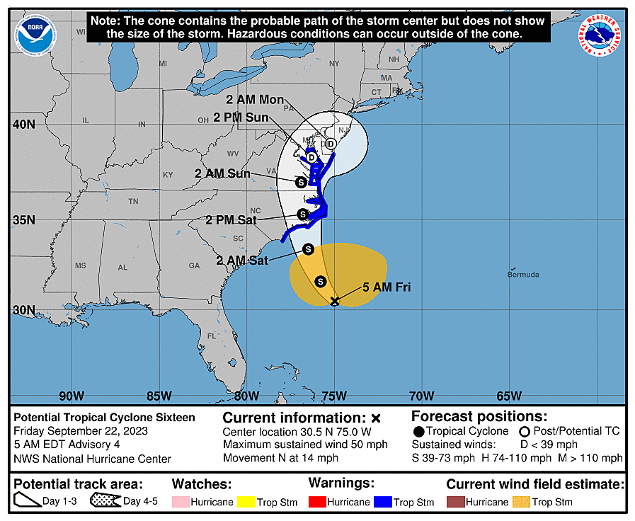
As of 5 a.m. Friday, Potential Tropical Cyclone #16 is centered just under 400 miles east of the Florida-Georgia line. That puts it about 600 miles south of Cape May, New Jersey. It is expected to become a tropical storm later Friday — the next name on the Atlantic hurricane list is Ophelia. A landfall along the Outer Banks of North Carolina is likely midday Saturday.
This will turn into a multi-impact storm for New Jersey. Given the latest jog to the west, suggesting a more inland storm track, I'm actually thinking the wind and coastal flooding threats will overshadow the risk of heavy rain and flash flooding. Don't get me wrong — it is still going to be very wet this weekend, with big puddles all around the state. But 3 inches of rain over 48 hours is a much better situation than 3 inches of rain in an hour or two.
When will we dry out? Good question. Hopefully sometime Monday?
When will we see the sun again? An even better question. Maybe October?
Timeline
As we all carefully ponder those "Rain or Shine" plans for the weekend, let me run through a detailed timeline of how the stormy weather will play out.
—Friday Daytime... Fine. Dry. No problems. Mostly cloudy to overcast skies will keep temperatures in check, only warming to around 70 degrees in the afternoon. It will turn breezy, but that's it.
—Friday Evening... Initial showers will bubble up into South Jersey around sunset Friday, spreading north throughout the night.
—Friday Late Night... By early Saturday morning, it will be raining everywhere in the state. And rainfall will become steadier and heavier, with gusty winds kicking in by daybreak Saturday.
—Saturday Morning... The first brunt of the storm. Pockets of heavy rain will combine with the strongest winds of the entire weekend.
—Saturday Afternoon... Rain actually dials back, as we catch some lulls and breaks of dry weather. It will still feel damp, cloudy, and cool. And it will still be windy. Coastal flooding concerns will peak starting mid-afternoon, as high tide arrives. Models are showing modest instability building in late afternoon, so any scattered pockets of rain could include some thunder and lightning.
—Saturday Night... Eventually, as the center of low pressure approaches New Jersey, rain will pick up again. Ambient wind speeds will be less intense than during the daytime hours, but there will be a severe thunderstorm threat.
—Sunday Morning... Still wet, breezy, and potentially stormy.
—Sunday Afternoon... Scattered rain rolls right along, drifting north and east as the day goes on. At the same time, there is a chance for peeks of sun if we get dry-slotted, especially south and west. That would send temperatures temporarily shooting into the 70s.
—Monday... I'm keeping fingers crossed that showers will come to an end around daybreak Monday. But that is not a guarantee — some model guidance shows the storm stalling near New Jersey for much of next week, keeping spotty rain in the forecast.
Rain
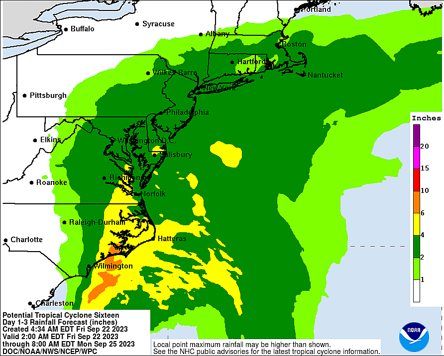
—When? It will likely be raining somewhere in New Jersey from Friday evening through Monday morning (at least). The heaviest spurts of rain are expected Saturday morning and again Sunday morning.
—How Much? Total rainfall will likely reach 2 to 3+ inches along NJ's coastal counties. (The "plus" suggests locally higher amounts are possible, to 4 or even 5 inches.) Farther inland, totals will be closer to 1 to 2 inches. That's a lot of water — flooding of low-lying or poor-drainage areas is possible.
—Advisories? None at this time.
—Action Steps? Bring in anything that can't get soaked by wind-driven wind. Plan your weekend carefully to avoid traveling in downpours. If flooding occurs, do not attempt to walk, drive, or swim through it.
Wind
—When? The strongest wind gusts will blow through New Jersey during the Saturday daytime hours.
—How Strong? Wind gusts may top 50 mph along the Jersey Shore Saturday morning. Inland South Jersey could hit 40 mph. To the north and west, top gusts will be closer to 30 mph.
—Advisories? A High Wind Warning has been issued for coastal Atlantic and Cape May counties from Midnight to 8 p.m. Saturday. A Wind Advisory covers the rest of the coast from 6 a.m. to 8 p.m. Saturday.
—Action Steps? Secure any outdoor items that could become projectiles in high wind, including garbage cans, umbrellas, lawn furniture, and toys. Be prepared for power outages by keeping electronics charged and flashlights handy. Expect driving difficulties due to strong crosswinds and/or downed trees and branches.
Severe Weather
—When? Frankly, gusty winds and an isolated tornado are possible at any time during the storm's timeline. But especially from late Saturday to early Sunday.
—How Bad? It is not our primary concern, but worth mentioning. The greatest risk of a quick spin-up will be along NJ's southern coast.
—Advisories? None.
—Action Steps? If warnings are issued, seek shelter immediately on the lowest level of a sturdy building.
Coastal Flooding
—When? Only the Saturday afternoon/evening high tide cycle is especially concerning. Oceanfront high tide is around 2 p.m. Saturday. Back bays will crest a few hours later, around 5 p.m. The Delaware River will rise through about 8 p.m. Saturday evening.
—How High? The official storm surge forecast calls for 1 to 3 feet of water pushing up against the Jersey Shore. That is enough for tide levels to exceed Moderate flood stage, especially along the southern coast (Ocean to Atlantic to Cape May counties). Note: Delaware beaches are forecast to hit the Major flooding category. This could be a pretty significant tidal flooding event.
—Advisories? A Coastal Flood Warning has been issued for Ocean, southeastern Burlington, Atlantic, and Cape May counties. Coastal Flood Advisories are posted for Middlesex, Monmouth, Cumberland, and Salem counties.
—Action Steps? This level of flooding goes beyond "the usual spots". Road closures may be necessary, and property damage is possible. If you live in an especially flood-prone area, you may want to move your vehicle to higher ground and protect outdoor belongings.
Rough Surf
—When? Now through the weekend.
—How Big? Waves will peak in the 4 to 8 foot range on Saturday.
—Advisories? A high risk of dangerous rip currents is posted for Jersey Shore beaches, for the foreseeable future.
—Action Steps? Stay out of the ocean.
What's Next?
Weather-wise, it looks like we will hold onto a prominent on-shore breeze next week, keeping skies cloudy and temperatures on the cool side. I've got highs only reaching the 60s all week — definitely feeling like fall. Our next chance of rain would be in the second half of next week, in the Wednesday-Thursday-Friday time frame. Our next chance of a bright sunny day unfortunately won't come until the following week. Which is already October.
As New Jersey's weather turns nasty this weekend, our news, weather, traffic, programming, and digital teams are ready to keep you prepared and informed for the duration. Whether conditions are dangerous or just inclement, we will have full coverage on-air and online for the duration. (I will be on the weather desk for most of Saturday.)
Be safe and stay smart out there.
Your hurricane emergency kit: what to pack
Dan Zarrow is Chief Meteorologist for Townsquare Media New Jersey. Follow him on Facebook for the latest forecast and realtime weather updates.