
Ophelia’s not-so-grand finale: When will NJ’s rain and wind end?
The Bottom Line
On Saturday, Tropical Storm Ophelia proved to be just as nasty as expected. Especially along the Jersey Shore.
Total rainfall ranged from a healthy half-inch in northwestern New Jersey, to over 4 inches in spots along the coast. As of Midnight, Berkeley Township reported 4.90" of rain, Toms River 3.90", and Cape May Courthouse 3.71".
Meanwhile, winds roared along the Shore, causing sporadic power outages and making for some incredible waves on the Atlantic Ocean. Top wind gusts were 62 mph in North Beach Haven, 61 mph at Sea Isle City, and 61 mph in Tuckerton. For counties not bordering the ocean, winds were much tamer — some weather stations along the Delaware River did not even hit 20 mph.
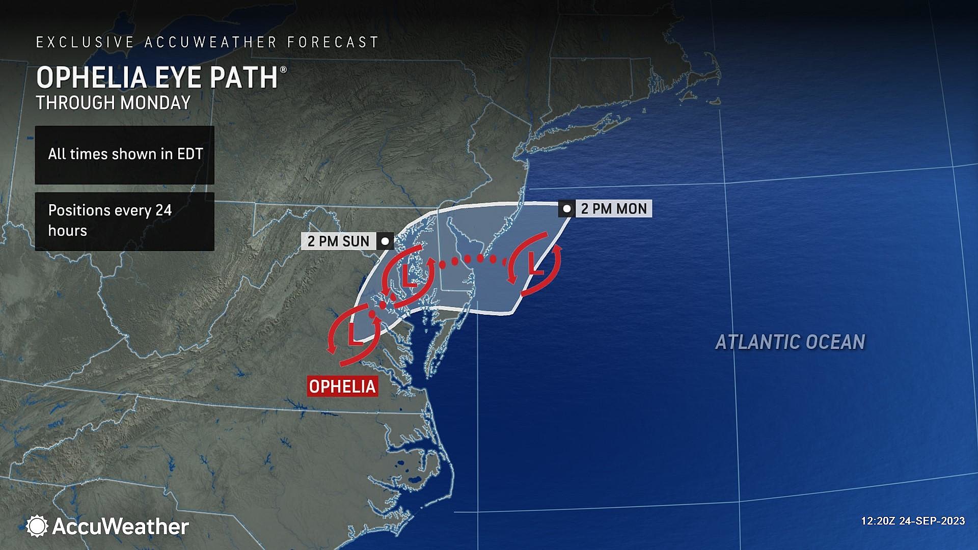
The coastal flooding was dramatic too, although mitigated somewhat due to the lower astronomical tide this week. One water gauge — on the Great Egg Harbor Bay in Ocean City, N.J. — reached an inch or two above "moderate" flood stage.
Looking forward, all three of those threats — rain, wind, and coastal flooding — will be lower on Sunday. Yes, the brunt of the storm is behind us now. Sunday will still be an inclement day, but with fewer alarm bells to ring.
Frankly, Ophelia is running out of gas. As of early Sunday morning, Ophelia's low was declared no longer tropical. As of this writing (8 a.m. Sunday), the circulation of those remnants is centered over Maryland.
After 24+ hours of driving rain and wind, most New Jerseyans are ready for some drier, quieter weather. Unfortunately, we still have to wait another day or two for Ophelia's impacts to fully subside here.

Rain
Overall, Sunday will feel like an unsettled, damp day as pockets of rain and drizzle pass through New Jersey all day.
There could be some pockets of steadier, heavier stuff along the way. (I suspect forecast models are overdoing possibility of torrential, tropical rain.) Maybe even a rumble of thunder, especially along the coast. (Remember: When thunder roars, head indoors.) The threat of severe weather (wind, hail, tornado) is very low going forward.
An additional inch of rainfall is possible. Alone, that amount of water does not pose an especially serious problem. But with a soaking wet, saturated ground, any downpour could quickly lead to "big puddles" — ponding and/or flooding issues. Just stay alert to that possibility if you're out and about Sunday.
Ophelia's remnant low will exit off-shore early Monday morning. But while it's still in the neighborhood, we will still get wet. In fact, I've had to extend rain chances well into Monday afternoon, especially along the NJ coast.
It's even possible to see some showers along the eastern edge of New Jersey on Tuesday too, depending on how quickly (or slowly) Ophelia's remnants shoot to the east. At the very least, clouds and a stiff breeze will linger for another day.
Hopefully we will enjoy some "nice" weather days on Wednesday and Thursday. Skies will be partly sunny. But high temperatures stay below normal for late September, only in the 60s.
Wind
No more 50-60 mph gusts. We are looking at 20-30 mph wind gusts for inland New Jersey on Sunday. And the coast will remain windswept, with top gusts in the 30-40 mph range.
The good news — those wind speeds will continue to slowly diminish as the day goes on.
The bad news — as Ophelia's low pressure center hits the ocean water Monday afternoon, it will strengthen ticking wind speeds upward again. Probably to this same 20 mph inland, 40 mph vicinity.
We have no advisories for wind left in effect at this point. Widespread power outages are not expected. It's just a nuisance, potentially making driving and walking difficult. And keeping the surf rough.
Coastal Flooding
The next precarious high tide cycle is coming up around 3-4 p.m. along the oceanfront and 6-7 p.m. for back bays. Widespread minor flooding of tidal waterways is forecast, and a Coastal Flood Advisory is posted as a result.
The back bays are still pretty full of water from Saturday's high tide, thanks in large part to the persistent on-shore wind. So I am concerned that tidal guidance is underestimating water levels in especially vulnerable locations. We could come very close to moderate flood stage again in spots Sunday evening — something to watch.
Monday's late-day high tide cycle may also produce a round of minor flooding.
And then we run into a new problem: the impending full moon on Friday. As we approach that point in the lunar cycle, the astronomical tide will increase. And with extra Ophelia water still stuck in our tidal waterways, a resurgence of minor to moderate flooding may occur.
Long-range models do show another coastal storm system arriving around late-week. I would not hang my hat on the forecast this far out. But that could be even more impactful than Ophelia, given the higher ambient tide and the fact that our beaches and dune systems are hurting after this weekend's battering.
In other words, it could be another rough week for the Jersey Shore.
Tropical Storm Ophelia's Impacts in Ocean City
Dan Zarrow is Chief Meteorologist for Townsquare Media New Jersey. Follow him on Facebook for the latest forecast and realtime weather updates.