Flash flooding and tornadoes: NJ county by county breakdown of Ida’s impact
A TORNADO WATCH has been issued until 10 p.m. for most of New Jersey including Alantic, Burlington, Camden, Cape May, Cumberland, Gloucester, Hunterdon, Mercer, Middlesex, Monmouth, Morris, Ocean, Salem, Somerset and Warren counties.
Ida Overview
It is the first day of September and the first day of climatological autumn. It is also "Ida Day" for New Jersey, as the remnants of the once-powerful hurricane pass directly overhead.
Since Ida first formed almost a week ago, the forecast has remained remarkably consistent. The storm will have significant impacts on New Jersey over the next 24 hours, with heavy rain, flooding, and severe weather (i.e. tornadoes) on the way. (However, Ida is NOT going to be a huge wind, power outage, storm surge, coastal flooding, rough surf machine.)
Wednesday's daytime hours will be dreary and unsettled, as Ida's initial rain bands move through. Models do show some embedded downpours or strong thunderstorm cells too.
Then things turn nasty and really stormy. The brunt of the storm — the time of the heaviest rain and highest tornado risk — will start Wednesday evening. 6 p.m. to 4 a.m. Both the arrival and departure are slightly earlier than we've advertised previously.
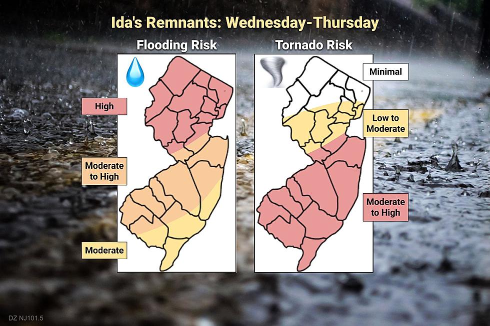
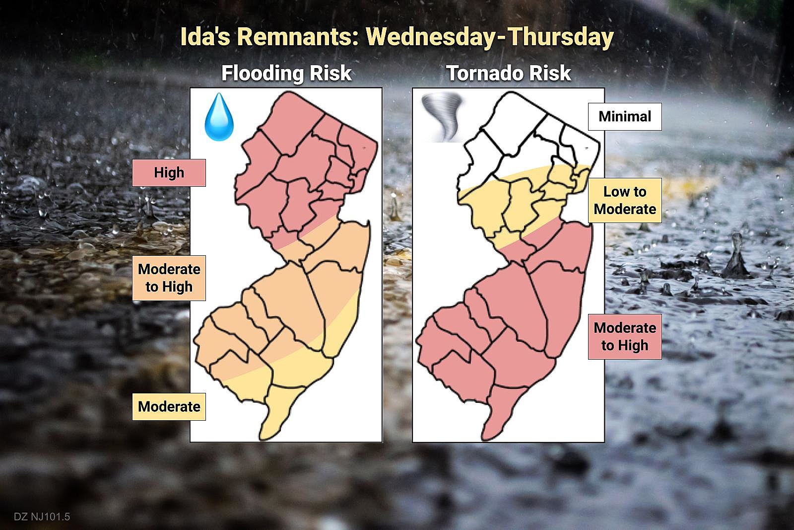
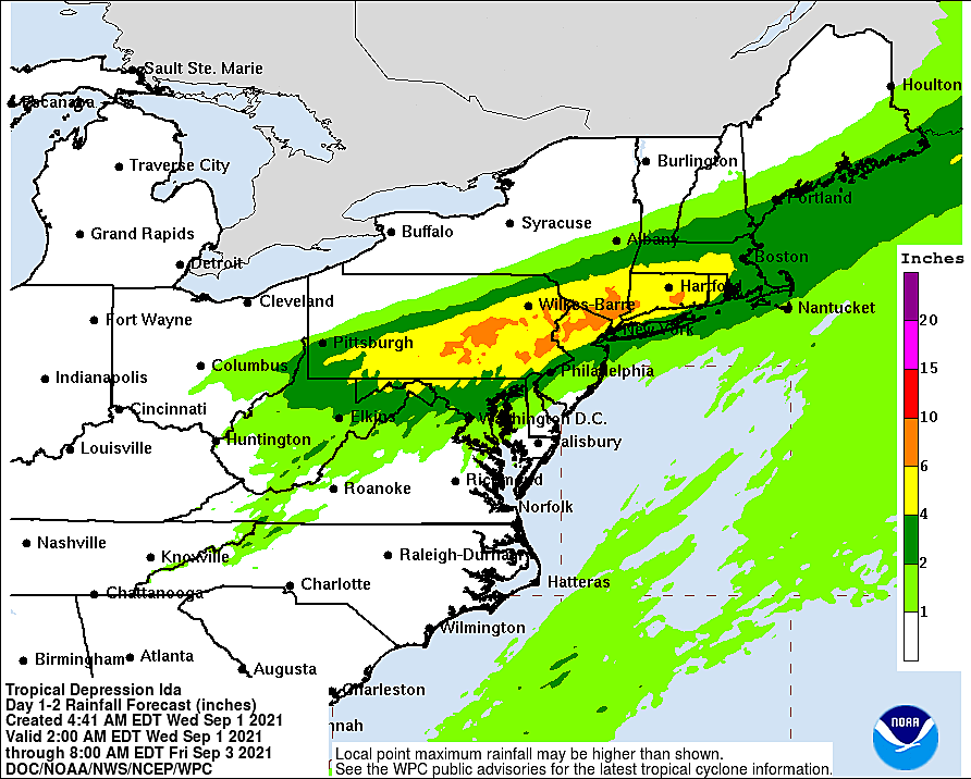
Top rainfall totals will be found across approximately the northern half of the state, on the order of 3 to 6+ inches. As we have discussed, the "plus" is very important — if tropical rain bands become stagnant or "train" (form and re-form repeatedly over the same area), locally higher amounts are possible.
A Flash Flood Watch has been issued for all 21 counties of New Jersey from Wednesday morning through Thursday morning. Waterways will rise quickly during and after troipcal rainfall, with minor to moderate flooding expected across many rivers, streams, and creeks. (Especially around the Passaic River and Raritan River basins.)
Meanwhile, the southern half of the state isn't out of the woods. Even though rainfall totals will be lower, downpours could still inundate storm drainage systems and cause ponding and flooding issues. Plus, South Jersey be the area of the greatest tornado threat — something that should not be ignored here.
It would be a good night to just stay in and hunker down, if possible. At the very least, remember to never attempt to drive, swim, or walk through flooded areas. And with regard to severe weather, if a warning is issued for your area, seek shelter immediately in a sturdy building.

By daybreak Thursday morning, it'll all be over. As the storm flies off to the northeast, the rain will end. You may still want to leave yourself some extra time for Thursday morning's commute, as some roads may be flooded out and detoured.
We should see sunshine across the state by Noon Thursday at the latest.
For the rest of this post, I'm going to break down Ida's approximate timing and impacts county-by-county. Hopefully this overview lets you plan your day and stay safe.
Atlantic
—Daytime Wednesday... One or two waves of rain are possible during the daytime hours. Maybe a strong storm cell along the way.
—The Brunt Begins... 8pm Wednesday evening
—Calming Down... 4am Thursday morning
—Flash Flooding Threat... Low to moderate. Ida's heaviest rain will stay to the north. But there is a reasonable chance of localized downpours causing temporary flooding and ponding on roadways and other low-lying areas.
—Tornado Threat... Moderate to high. On the convective (southern) side of Ida's center, severe thunderstorms could spawn strong winds and a few tornadoes.
—Total Rainfall... 0.5 to 1.5+ inches
—Max Wind Gusts... 40+ mph
—Storm Surge... 1 foot of storm surge may cause minor flooding of tidal waterways on Thursday, potentially made worse by heavy rainfall and runoff.
Bergen
—Daytime Wednesday... A few waves of rain are likely during Wednesday's daytime hours, with some embedded downpours or strong thunderstorm cells possible.
—The Brunt Begins... 8pm Wednesday evening
—Calming Down... 4am Thursday morning
—Flash Flooding Threat... High. Prolonged heavy rain could inundate storm drains. Rivers, streams, and creeks will run high and fast.
—Tornado Threat... Minimal. The greatest shear and highest risk of severe storm cells and tornadoes will stay south.
—Total Rainfall... 3 to 6+ inches
—Max Wind Gusts... 40+ mph
Burlington
—Daytime Wednesday... A few waves of rain are likely during Wednesday's daytime hours, with some embedded downpours or strong thunderstorm cells possible.
—The Brunt Begins... 6pm Wednesday evening
—Calming Down... 2am Thursday morning
—Flash Flooding Threat... Moderate. Pockets of heavy rain could inundate storm drains. Rainfall and runoff could push waterways past flood stage.
—Tornado Threat... Moderate to high. On the convective (southern) side of Ida's center, severe thunderstorms could spawn strong winds and a few tornadoes.
—Total Rainfall... 2 to 3+ inches
—Max Wind Gusts... 30+ mph
Camden
—Daytime Wednesday... A few waves of rain are likely during Wednesday's daytime hours, with some embedded downpours or strong thunderstorm cells possible.
—The Brunt Begins... 6pm Wednesday evening
—Calming Down... 2am Thursday morning
—Flash Flooding Threat... Moderate. Pockets of heavy rain could inundate storm drains. Rainfall and runoff could push waterways past flood stage.
—Tornado Threat... Moderate to high. On the convective (southern) side of Ida's center, severe thunderstorms could spawn strong winds and a few tornadoes.
—Total Rainfall... 1 to 2+ inches
—Max Wind Gusts... 30+ mph
Cape May
—Daytime Wednesday... One or two waves of rain are possible during the daytime hours. Maybe a strong storm cell along the way.
—The Brunt Begins... 8pm Wednesday evening
—Calming Down... 4am Thursday morning
—Flash Flooding Threat... Low to moderate. Ida's heaviest rain will stay to the north. But there is a reasonable chance of localized downpours causing temporary flooding and ponding on roadways and other low-lying areas.
—Tornado Threat... Moderate to high. On the convective (southern) side of Ida's center, severe thunderstorms could spawn strong winds and a few tornadoes.
—Total Rainfall... 0.5 to 1.5+ inches
—Max Wind Gusts... 40+ mph
—Storm Surge... 1 foot of storm surge may cause minor flooding of tidal waterways on Thursday, potentially made worse by heavy rainfall and runoff.
Cumberland
—Daytime Wednesday... One or two waves of rain are possible during the daytime hours. Maybe a strong storm cell along the way.
—The Brunt Begins... 7pm Wednesday evening
—Calming Down... 3am Thursday morning
—Flash Flooding Threat... Low to moderate. Ida's heaviest rain will stay to the north. But there is a reasonable chance of localized downpours causing temporary flooding and ponding on roadways and other low-lying areas.
—Tornado Threat... Moderate to high. On the convective (southern) side of Ida's center, severe thunderstorms could spawn strong winds and a few tornadoes.
—Total Rainfall... 1 to 2+ inches
—Max Wind Gusts... 40+ mph
—Storm Surge... 1 foot of storm surge may cause minor flooding of tidal waterways on Thursday, potentially made worse by heavy rainfall and runoff.
Essex
—Daytime Wednesday... A few waves of rain are likely during Wednesday's daytime hours, with some embedded downpours or strong thunderstorm cells possible.
—The Brunt Begins... 8pm Wednesday evening
—Calming Down... 4am Thursday morning
—Flash Flooding Threat... High. Prolonged heavy rain could inundate storm drains. Rivers, streams, and creeks will run high and fast.
—Tornado Threat... Low, but not Zero. Depends on the exact storm track, as strong thunderstorms and isolated tornadoes are possible along and just south of Ida's center.
—Total Rainfall... 3 to 6+ inches
—Max Wind Gusts... 40+ mph
Gloucester
—Daytime Wednesday... A few waves of rain are likely during Wednesday's daytime hours, with some embedded downpours or strong thunderstorm cells possible.
—The Brunt Begins... 6pm Wednesday evening
—Calming Down... 2am Thursday morning
—Flash Flooding Threat... Moderate. Pockets of heavy rain could inundate storm drains. Rainfall and runoff could push waterways past flood stage.
—Tornado Threat... Moderate to high. On the convective (southern) side of Ida's center, severe thunderstorms could spawn strong winds and a few tornadoes.
—Total Rainfall... 1 to 2+ inches
—Max Wind Gusts... 30+ mph
Hudson
—Daytime Wednesday... A few waves of rain are likely during Wednesday's daytime hours, with some embedded downpours or strong thunderstorm cells possible.
—The Brunt Begins... 8pm Wednesday evening
—Calming Down... 4am Thursday morning
—Flash Flooding Threat... High. Prolonged heavy rain could inundate storm drains. Rivers, streams, and creeks will run high and fast.
—Tornado Threat... Low, but not Zero. Depends on the exact storm track, as strong thunderstorms and isolated tornadoes are possible along and just south of Ida's center.
—Total Rainfall... 3 to 6+ inches
—Max Wind Gusts... 40+ mph
—Storm Surge... 1 foot of storm surge may cause minor flooding of tidal waterways on Thursday, potentially made worse by heavy rainfall and runoff.
Hunterdon
—Daytime Wednesday... A few waves of rain are likely during Wednesday's daytime hours, with some embedded downpours or strong thunderstorm cells possible.
—The Brunt Begins... 6pm Wednesday evening
—Calming Down... 2am Thursday morning
—Flash Flooding Threat... High. Prolonged heavy rain could inundate storm drains. Rivers, streams, and creeks will run high and fast.
—Tornado Threat... Low, but not Zero. Depends on the exact storm track, as strong thunderstorms and isolated tornadoes are possible along and just south of Ida's center.
—Total Rainfall... 3 to 6+ inches
—Max Wind Gusts... 40+ mph
Mercer
—Daytime Wednesday... A few waves of rain are likely during Wednesday's daytime hours, with some embedded downpours or strong thunderstorm cells possible.
—The Brunt Begins... 6pm Wednesday evening
—Calming Down... 2am Thursday morning
—Flash Flooding Threat... High. Prolonged heavy rain could inundate storm drains. Rivers, streams, and creeks will run high and fast.
—Tornado Threat... Moderate to high. On the convective (southern) side of Ida's center, severe thunderstorms could spawn strong winds and a few tornadoes.
—Total Rainfall... 2 to 4+ inches
—Max Wind Gusts... 30+ mph
Middlesex
—Daytime Wednesday... One or two waves of rain are possible during the daytime hours. Maybe a strong storm cell along the way.
—The Brunt Begins... 8pm Wednesday evening
—Calming Down... 4am Thursday morning
—Flash Flooding Threat... High. Prolonged heavy rain could inundate storm drains. Rivers, streams, and creeks will run high and fast.
—Tornado Threat... Moderate to high. On the convective (southern) side of Ida's center, severe thunderstorms could spawn strong winds and a few tornadoes.
—Total Rainfall... 2 to 4+ inches
—Max Wind Gusts... 35+ mph
—Storm Surge... 1 foot of storm surge may cause minor flooding of tidal waterways on Thursday, potentially made worse by heavy rainfall and runoff.
Monmouth
—Daytime Wednesday... One or two waves of rain are possible during the daytime hours. Maybe a strong storm cell along the way.
—The Brunt Begins... 8pm Wednesday evening
—Calming Down... 4am Thursday morning
—Flash Flooding Threat... Moderate. Pockets of heavy rain could inundate storm drains. Rainfall and runoff could push waterways past flood stage.
—Tornado Threat... Moderate to high. On the convective (southern) side of Ida's center, severe thunderstorms could spawn strong winds and a few tornadoes.
—Total Rainfall... 2 to 3+ inches
—Max Wind Gusts... 40+ mph
—Storm Surge... 1 foot of storm surge may cause minor flooding of tidal waterways on Thursday, potentially made worse by heavy rainfall and runoff.
Morris
—Daytime Wednesday... A few waves of rain are likely during Wednesday's daytime hours, with some embedded downpours or strong thunderstorm cells possible.
—The Brunt Begins... 7pm Wednesday evening
—Calming Down... 3am Thursday morning
—Flash Flooding Threat... High. Prolonged heavy rain could inundate storm drains. Rivers, streams, and creeks will run high and fast.
—Tornado Threat... Minimal. The greatest shear and highest risk of severe storm cells and tornadoes will stay south.
—Total Rainfall... 3 to 6+ inches
—Max Wind Gusts... 40+ mph
Ocean
—Daytime Wednesday... One or two waves of rain are possible during the daytime hours. Maybe a strong storm cell along the way.
—The Brunt Begins... 8pm Wednesday evening
—Calming Down... 4am Thursday morning
—Flash Flooding Threat... Moderate. Pockets of heavy rain could inundate storm drains. Rainfall and runoff could push waterways past flood stage.
—Tornado Threat... Moderate to high. On the convective (southern) side of Ida's center, severe thunderstorms could spawn strong winds and a few tornadoes.
—Total Rainfall... 1 to 2+ inches
—Max Wind Gusts... 40+ mph
—Storm Surge... 1 foot of storm surge may cause minor flooding of tidal waterways on Thursday, potentially made worse by heavy rainfall and runoff.
Passaic
—Daytime Wednesday... A few waves of rain are likely during Wednesday's daytime hours, with some embedded downpours or strong thunderstorm cells possible.
—The Brunt Begins... 7pm Wednesday evening
—Calming Down... 4am Thursday morning
—Flash Flooding Threat... High. Prolonged heavy rain could inundate storm drains. Rivers, streams, and creeks will run high and fast.
—Tornado Threat... Minimal. The greatest shear and highest risk of severe storm cells and tornadoes will stay south.
—Total Rainfall... 3 to 6+ inches
—Max Wind Gusts... 40+ mph
Salem
—Daytime Wednesday... A few waves of rain are likely during Wednesday's daytime hours, with some embedded downpours or strong thunderstorm cells possible.
—The Brunt Begins... 6pm Wednesday evening
—Calming Down... 2am Thursday morning
—Flash Flooding Threat... Moderate. Pockets of heavy rain could inundate storm drains. Rainfall and runoff could push waterways past flood stage.
—Tornado Threat... Moderate to high. On the convective (southern) side of Ida's center, severe thunderstorms could spawn strong winds and a few tornadoes.
—Total Rainfall... 1 to 2+ inches
—Max Wind Gusts... 40+ mph
—Storm Surge... 1 foot of storm surge may cause minor flooding of tidal waterways on Thursday, potentially made worse by heavy rainfall and runoff.
Somerset
—Daytime Wednesday... A few waves of rain are likely during Wednesday's daytime hours, with some embedded downpours or strong thunderstorm cells possible.
—The Brunt Begins... 7pm Wednesday evening
—Calming Down... 3am Thursday morning
—Flash Flooding Threat... High. Prolonged heavy rain could inundate storm drains. Rivers, streams, and creeks will run high and fast.
—Tornado Threat... Low, but not Zero. Depends on the exact storm track, as strong thunderstorms and isolated tornadoes are possible along and just south of Ida's center.
—Total Rainfall... 3 to 6+ inches
—Max Wind Gusts... 35+ mph
Sussex
—Daytime Wednesday... A few waves of rain are likely during Wednesday's daytime hours, with some embedded downpours or strong thunderstorm cells possible.
—The Brunt Begins... 7pm Wednesday evening
—Calming Down... 3am Thursday morning
—Flash Flooding Threat... High. Prolonged heavy rain could inundate storm drains. Rivers, streams, and creeks will run high and fast.
—Tornado Threat... Minimal. The greatest shear and highest risk of severe storm cells and tornadoes will stay south.
—Total Rainfall... 3 to 6+ inches
—Max Wind Gusts... 30+ mph
Union
—Daytime Wednesday... A few waves of rain are likely during Wednesday's daytime hours, with some embedded downpours or strong thunderstorm cells possible.
—The Brunt Begins... 8pm Wednesday evening
—Calming Down... 4am Thursday morning
—Flash Flooding Threat... High. Prolonged heavy rain could inundate storm drains. Rivers, streams, and creeks will run high and fast.
—Tornado Threat... Low, but not Zero. Depends on the exact storm track, as strong thunderstorms and isolated tornadoes are possible along and just south of Ida's center.
—Total Rainfall... 3 to 6+ inches
—Max Wind Gusts... 40+ mph
Warren
—Daytime Wednesday... A few waves of rain are likely during Wednesday's daytime hours, with some embedded downpours or strong thunderstorm cells possible.
—The Brunt Begins... 6pm Wednesday evening
—Calming Down... 2am Thursday morning
—Flash Flooding Threat... High. Prolonged heavy rain could inundate storm drains. Rivers, streams, and creeks will run high and fast.
—Tornado Threat... Minimal. The greatest shear and highest risk of severe storm cells and tornadoes will stay south.
—Total Rainfall... 3 to 6+ inches
—Max Wind Gusts... 30+ mph
Oh, You Scrolled This Far Down?
Then let me share some very good news in the forecast after the storm. Thursday, Friday, and Saturday look like fantastic days, with mostly to partly sunny skies and high temperatures in the comfortable 70s. Our next chance of rain will come late Sunday into Monday. New Jersey faces no other significant storm systems or imminent tropical threats for the foreseeable future. (Although we do have Tropical Depression Kate and Tropical Storm Larry churning up the Atlantic at the moment.)
Be smart and stay safe out there today and tonight.. We'll be here with you, on-air and online, until Ida's final raindrops fall.
Dan Zarrow is Chief Meteorologist for Townsquare Media New Jersey. Follow him on Facebook or Twitter for the latest forecast and realtime weather updates.
9 amazing facts about lightning you probably didn’t know
BEEP BEEP BEEP: These are the 13 types of Wireless Emergency Alerts auto-pushed to your phone
More From 105.7 The Hawk


