A bit of rain/snow Friday – weekend nor’easter a snowier scenario for NJ
The Bottom Line
Friday's little storm system will be no big deal — NW NJ could see an inch or two of snow accumulation. The bigger deal here is the complete "180" an impending coastal storm system has made. With a track now expected to hug the East Coast, we now fall squarely within this potential nor'easter's grasp. Accumulating snow looks likely, especially the farther south in new Jersey you go. The big question: Will it be a little bit of snow, or a lot?
Friday
A weak wave of precipitation will pass through New Jersey throughout Friday morning. As of this writing (5:30 a.m.), the freezing line is running right across the southern edge of Hunterdon, Somerset, and Union counties. So, for areas north and west of that line, it's going to be mainly snow. To the south, it's going to be mainly rain. (With some mixing possible in Middlesex and Mercer counties, perhaps.)

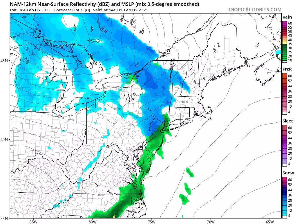
Anything that falls from the sky will be light to occasionally moderate in intensity. The "snow zone" in North Jersey could see an inch or two of fresh accumulation by midday. Conversational snow. The "rain zone" will only pick up about a tenth of an inch in the rain gauge.
There could be slippery spots. And rain will accelerate snow melt, possibly causing some big puddles. Other than that, there are no huge concerns here.
We should dry out Friday afternoon, with some breaks in the cloud cover late-day. Most high temperatures will push into the 40 to 45 degree range.
Skies will continue to clear Friday night, with statewide low temperatures averaging upper 20s.
Saturday
A good-looking early February day! Mostly sunny skies will meet a stiff southwesterly breeze, possibly gusting between 20 and 30 mph. High temperatures will be on the mild side, reaching the mid 40s for all but far nothern NJ.
Clouds will start to roll back in Saturday evening.
Sunday
Really?! Another nor'easter?! Dan, say it ain't so?!
Sigh. It's so.
First of all, this is not like Monday's storm — this is the other kind of nor'easter. A "Miller Type A" is born in the Gulf of Mexico, and parallels the entire Atlantic seaboard as it travels northeast. Sometimes they eject out to sea after passing the Outer Banks of North Carolina — that's why earlier this week, I had declared this storm "probably a miss".
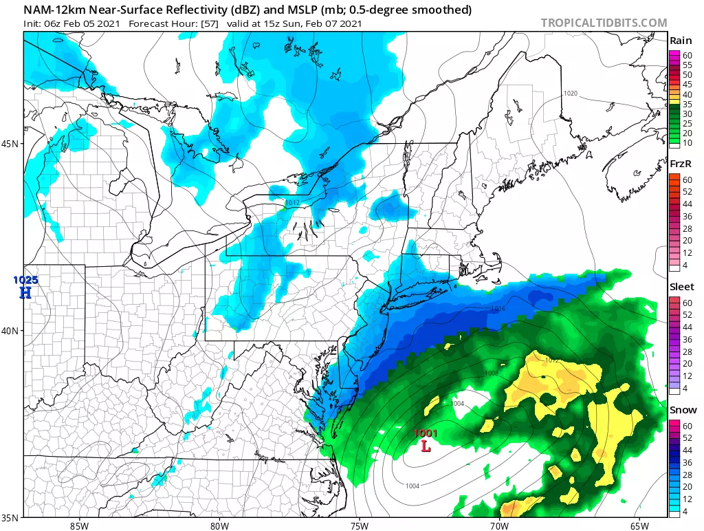
Well, the latest model guidance overwhelmingly suggests the storm track will stay close to the coast as it approaches New Jersey. (You should have seen my face and heard my colorful language when I saw that Thursday afternoon.) That means a (much) snowier scenario for us on Sunday.
—The reason for the flip? It's all about the Bermuda high — a huge, semi-permanent dome of sinking air over the middle of the Atlantic Ocean. Models are now painting that high to be 1.) stronger and 2.) farther west, pushing our coastal storm up against the wall (i.e. the coast).
—Could it flip back? Sure. In fact, the precise storm track (a.k.a. the "wiggle factor") will have a dramatic effect on how much snow we see, ranging from "nothing" to "a lot". A little change in just 25 to 50 miles will make all the difference.
—Most likely scenario? I'm pretty convinced we're going to see at least some snow in southern and coastal New Jersey on Sunday. Unlike last Monday's snowstorm, this sucker would be moving very quickly. So it rolls in around 4 a.m. Sunday, and exits around Noon (give or take).
—Snow totals? Ah, there's the problem. About 24 hours ago, models went bonkers with up to a foot of snow over most of New Jersey. Things have settled down now (including my palpitating heart). At the moment, I'll say that North Jersey will see very little (if any) snowfall, while South Jersey has the potential for a few inches. Wow, a "South Jersey Special" — it's been a few years since we've had one of those!
Again, that estimate may change (even significantly) between now and first flakes. And that's why I'm not ready to draw a concrete snow map just yet.
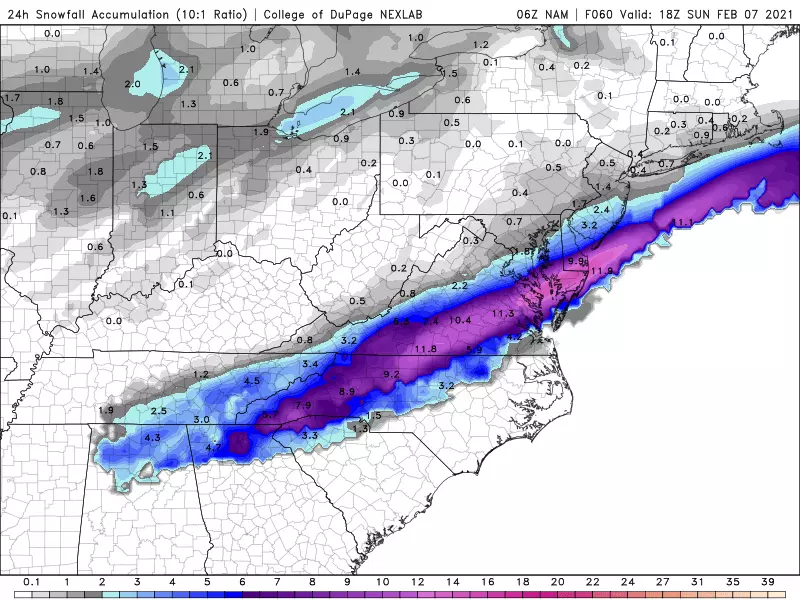
Usually I don't share maps of raw model snowfall. This represents one run of one model, deriving potential snowfall from zillions of atmospheric parameters. If just one of those variables is off, the forecast is wrong. (Garbage in, garbage out.)
But I think this model forecast (06Z NAM, 24-hour snowfall. as of Sunday afternoon) illustrates the ultimate challenge with this forecast. I could forecast about 2 to 4 inches of accumulation across the southern third to half of New Jersey, and call it a day. But look at that band of heavy snowfall — up to a foot — just a few miles south of New Jersey. That's a close scrape.
There will be a band of heavy snow associated with this storm. I think it will be cold enough to sustain snow for most of the storm's duration over New Jersey (even far south and coast). It's obviously a very dynamic situation too, with lots of "wiggling" potentially yet to come.
Again, it comes down to this: Will it be nothing or a little or a lot?
—What about the coast? Thankfully, I don't think storm surge and coastal flooding will be an issue this time around. The on-shore wind will not be as strong nor as prolonged as Monday's storm, keeping the surge estimate below a foot.
—So what's next? We are going to carefully watch how the atmosphere and model guidance trend over the next day. I expect to issue a snowfall forecast map either late Friday afternoon or early Saturday morning. If the snow forecast leans on the heavier side, you might see watches or advisories come out in that same time frame.
The Extended Forecast
No matter what the coastal storm dumps on New Jersey, we are facing another blast of cold wind next week. High temperatures on Monday will struggle to reach 30 degrees. But I don't think the core of this cold air pool will reach New Jersey. Not next week, at least. So it won't be frigid or bone-chillingly cold or dangerously cold. (You probably will see such headlines for the Great Lakes and Midwest regions.) Just unseasonable and somewhat unpleasant here.
There are a few rapid-fire storm system threats for next week too. One on Tuesday. Another Wednesday night to Thursday. And probably another one next weekend. Each with the potential of producing a few inches of snow somewhere in the state. We'll look more closely at those once Sunday's storm is out of our hair.
Next weather blog update probably coming Friday afternoon or early evening. Until then, have a Happy National Weatherperson's Day!
Dan Zarrow is Chief Meteorologist for Townsquare Media New Jersey. Follow him on Facebook or Twitter for the latest forecast and realtime weather updates.
What Are the Signature Drinks From Every State?
More From 105.7 The Hawk