
Thursday NJ weather: Not quite as steamy, another round of storms
The Bottom Line
Wednesday evening's thunderstorms did little to cut through the heat and humidity. While Thursday will be slightly less steamy, it will still be very warm and humid. And once again, we'll be watching the sky for stormy weather in the evening hours. Clouds and unsettled weather will make Friday the coolest day of the week, before thermometers get cooking again for the final weekend of July.

Wednesday Evening Thunderstorm Recap
Thursday
The heat and humidity dial back just enough to take us out of the danger zone Thursday, but it's still going to be a hot and humid summer day. A sticky start in the 70s, followed by afternoon high temperatures around 90 degrees. The heat index ("feels like" or "apparent" temperature) will push into the mid 90s. While we miss out on the "dangerous" heat index threshold of 100, a Heat Advisory has been posted for NE NJ (Bergen, Essex, Hudson, eastern Passaic, and Union counties) from Noon to 8 p.m.
We'll see a mix of sun and clouds throughout the day — so far, so good. As convection over Pennsylvania fizzles, we could see a few stray showers pass into New Jersey at any time today. (In fact, as of this writing — 5:15 a.m. — there is a weak little thunderstorm over Cumberland and Cape May counties.)
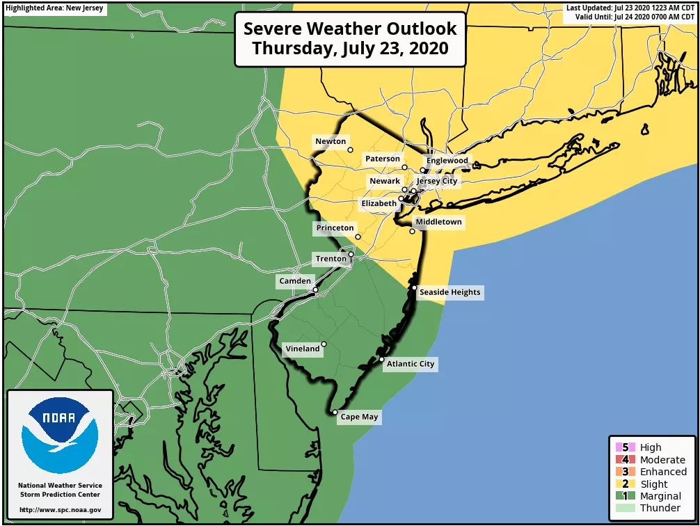
The best chance of thunderstorms Thursday will once again come in the evening hours, starting around 5 p.m. This round of stormy weather will be a little different than Wednesday's, for three important reasons: 1.) Thunderstorms won't be as widespread, with northern and western NJ under the gun for severe wind gusts and heavy downpours. 2.) Storms will largely fizzle as sunset approaches and as they get close to the (cooler, more stable) coast. 3.) Having said that, storms may not make a quick exit, with showers and damp weather potentially continuing overnight.
Friday
This has been a tough forecast all week. And models are still painting a few showers and thunderstorms in the neighborhood throughout the day, mainly early and late. Best chance for raindrops looks to be central and southern NJ. Given the humidity, some heavy rain is possible — one model does show a pocket of 2-3+ inches over the Interstate 195 corridor. Otherwise, we're facing lots of clouds and the (relatively) coolest day of the week. Highs will be limited to about 85 to 90 degrees.
Saturday
Diving into the last weekend of July, temperatures will heat up again. But Saturday reads like a pleasantly hot and humid summer day. Mostly sunny skies will push high temperatures to about 90 degrees. (That is technically about 5 degrees above normal for late July, but who cares.)
Sunday
The start of our next wave of excessive heat. High temperatures will soar to about 90 to 95 degrees, with a heat index flirting with triple digits. Skies sill be partly sunny. I have opted for a rain-free, storm-free forecast for the weekend.
Monday
More 90s. Probably heat advisories or warnings. Partly sunny, with a late-day thunderstorm chance.
The Extended Forecast
Tuesday looks ferociously hot too. Best-case scenario would be a cold front on Wednesday, which will knock back temperatures slightly and humidity dramatically. That means we could end July and start August with much more comfortable warm weather. Sounds good to me!
Dan Zarrow is Chief Meteorologist for Townsquare Media New Jersey. Follow him on Facebook or Twitter for the latest forecast and realtime weather updates.
More From 105.7 The Hawk

