The big cooldown: 40 to 60 mph wind gusts expected across NJ Friday
The Bottom Line
On each of the last three consecutive days, at least one location in New Jersey has hit 80+ degrees. (Including, of course, our first 90-degree day of the year on Wednesday.) It’s felt positively summerlike, especially with the high humidity and scattered thunderstorms.
Now, we look ahead to the inevitable cooldown. A strong cold front will pass west to east across New Jersey on Friday. As the rain and humidity exit, a fierce wind and cooler air will arrive.
At least the change will set up a decent weekend, with more seasonable temperatures.

Friday: The Rain
From rainy to breezy to gusty to chilly, Friday will be a big day of change for New Jersey.
The day begins where Thursday ended, with one final push of showers and thunderstorms in the early morning hours. It looks like raindrops will completely clear out by about 6 a.m. at the latest.
Model guidance does suggest the chance for isolated to spotty showers later Friday afternoon. It’s worth keeping that chance in the back of your mind, as the approaching cold front could cause enough lift to generate some rain. However, in general, I do believe we’ll enjoy brighter, clearer skies and predominantly dry weather for most of the day.
Friday: The Wind
Clearly “the big deal” of Friday’s big transition.
The early morning showers could get a bit gusty, especially if an embedded thunderstorm cell breaks out.
The majority of Friday daytime will fall into the “breezy” category, with regular westerly wind gusts to about 30 mph.
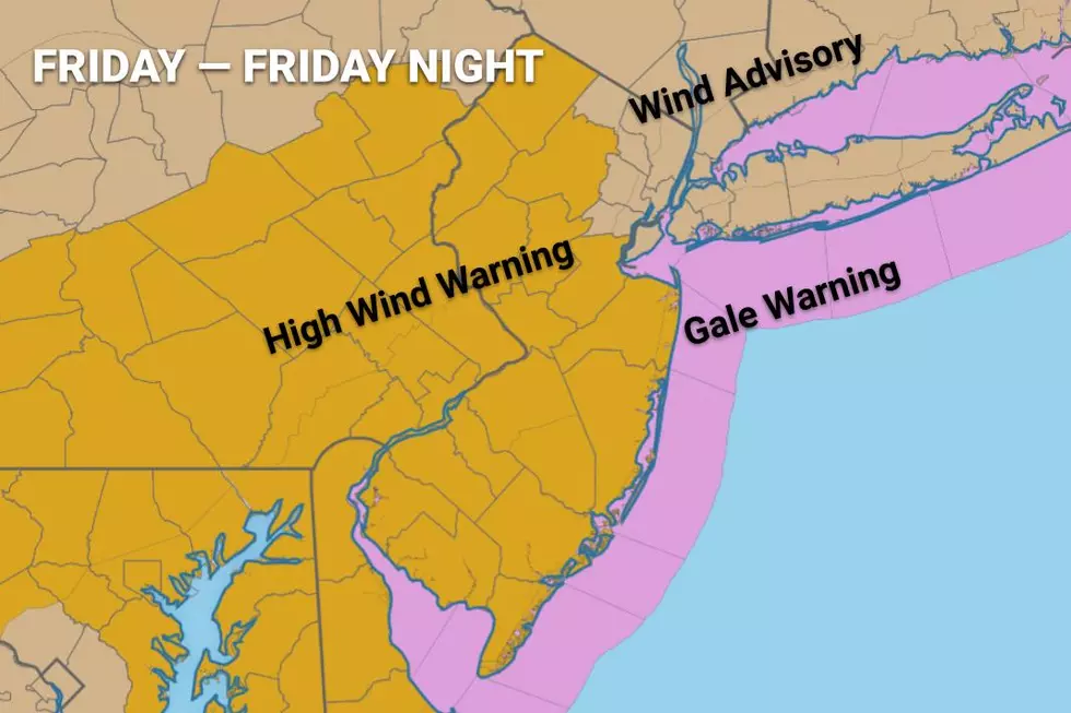
By the late afternoon and evening hours, the final cold frontal passage will bring the strongest winds of the day. These will blow from the west-northwest, with top gusts between about 40 and 60 mph. (I realize that’s a wide range of possible wind speeds, but fierce winds can be highly variable based on topography and other factors.)
A High Wind Warning and Wind Advisory have been issued across the state, through Friday night.
In such wind, garbage cans may become thoroughly relocated, unsecured lightweight items can become projectiles, and walking/driving will be difficult at times.
Friday: Temperatures
The ultimate result of the cold front will be much more seasonable temperatures to start the month of May.
Friday’s “high temperature” - the maximum reading on the thermometer all day - will likely occur just after Midnight, in the neighborhood of 70 degrees.
By Friday morning’s commute, lower humidity and clearer skies will allow temperatures to drop into the 50s. Still above seasonal normals, but more comfortable than the last two nights.
Temperatures will follow a diurnal trend, rising a bit through Friday early afternoon. We should see thermometers recover into the lower to mid 60s. Not bad, by late April standards.
Of course, once about 3 p.m. passes, temps will start to fall off. With rapid cooling expected after sunset.
By Saturday morning, we could see widespread 30s, away from urban and coastal areas. Cold enough for patchy frost in the coldest parts of New Jersey. Back to “jacket weather” for sure. Especially with the wind continuing to blow, potentially pushing wind chills into the 20s for some.
The Rest of the Forecast
Saturday will start cool and breezy. Then decreasing winds should make for a decent afternoon. High temperatures should reach the lower 60s, just below normal for the first of May. I’ve opted for a sunny, dry forecast during the day.
As a weak disturbance rides through our atmosphere, a quick batch of showers may moisten your Saturday evening and/or early Sunday morning plans. Best chance of rain would be 7 p.m. to 7 a.m. It won’t amount to much.
A return to southerly winds will easily make Sunday the warmer day of the weekend. 50s in the morning and 70s in the afternoon. Skies will be partly sunny.
The long-range outlook for next week shows alternating wet-dry days. I’m seeing scattered showers throughout Monday. Then a batch of steadier rain on Wednesday. And another storm system could drive in soaking rain for Friday too. Temperatures, meanwhile, will hover on either side of climatological normals for early May - generally in the 60s.
Please be smart and stay safe during April’s grand finale windstorm. And have a great weekend!
Dan Zarrow is Chief Meteorologist for Townsquare Media New Jersey. Follow him on Facebook or Twitter for the latest forecast and realtime weather updates.
When Ocean and Monmouth County Police saved the day
More From 105.7 The Hawk
