NJ weather: Two days of soaking rain, followed by a burst of snow
The good news... Monday and Tuesday will be relatively warm, with high temperatures popping into the 50s across most of the state.
The bad news... Monday and Tuesday will be quite wet, as a pair of storm systems deliver extended periods of rain.
More news... On the backside of this stormy setup, colder air could force a transition to snow Tuesday night into Wednesday morning.
(Whether that piece of information qualifies as good or bad depends on your personal opinion of winter!)

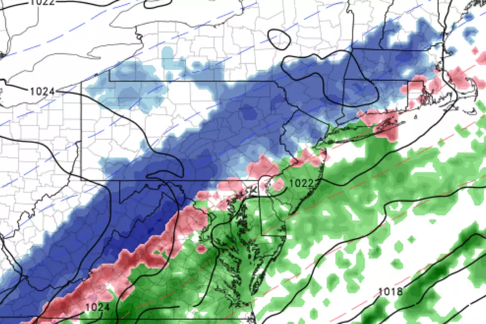
Let's start with the rain. It's already wet across the entire Garden State. Models are in pretty good agreement that this wet weather will come through the Garden State in two batches:
Round 1... The steadier, heavier round of rain will be from Monday morning through Monday late evening.
Round 2... Another round of (relatively) lighter rain will kick in starting around midday Tuesday, with precipitation ending completely by midday Wednesday.
Rainfall totals will reach a half-inch at the very least, no matter where in New Jersey you are. I suspect much of the state will probably top an inch of rain. The wettest spot will be somewhere between North Jersey and the NJ Turnpike corridor, where 2 inches of rain is a possibility. Definitely some healthy rainfall, all around. (Flash, river, and coastal flooding are not expected to be huge concerns here.)
Winds will be elevated too, generally sustained at 15 to 20 mph out of the south-southwest.
Again, so far we're just talking about plain ol' rain, as temperatures will hover in the mid 50s from Monday through Monday night. 60 degrees is a possibility at some point on Tuesday!
However, problems arise at the tail-end of this storm system, with colder air arriving as Tuesday night falls. Temperatures will dive past the freezing mark between 7 p.m. Tuesday and 2 a.m. Wednesday, as a cold front progresses from northwest to southeast. As it does, I suspect most of New Jersey will flip from rain to snow for a period through Wednesday morning.
Accumulating snow is a good possibility across the board. But there are three big obstacles to this snow forecast, potentially limiting how much white stuff ends up on the ground:
1.) The ground is going to be very wet from the rain. And therefore pretty warm. A quick, clean transition from rain to snow and a period of heavy snowfall can absolutely overcome that and cause the snow to "stick" and accumulate rapidly. But it will be challenging, especially on paved, non-elevated surfaces.
2.) Cold air is dry air. The timing of the subfreezing air has to be just right, happening before the end of the most substantial precipitation. I'm not convinced we're going to have enough moisture left for heavy snow, post-front.
3.) Things might not go all snow in South Jersey. My current forecast low temperature at ACY (Egg Harbor Township) Wednesday morning is 35 degrees. Sure it can snow at 35 — what happens about a mile up in the atmosphere is actually more important than the surface temperature. But a wintry mix (or even mainly rain) seems more likely at onset. And even if you do get a period of all snow, accumulation is going to be difficult.
In spots, it is going to snow for a good 6 to 9 hours. Enough to cause visibility issues and accumulate a bit. Raw model output puts North Jersey somewhere between about 4 and 7 inches of snowfall, while South Jersey gets a more limited 0 to 2 inches. However, I can tell you confidently that those numbers are too high, for the three reasons I just stated.
So let's cut those estimates in half, at least. 2 to 4 inches along and northwest of the NJ Turnpike corridor. More like 0 to 1 inches south and coast. That seems reasonable to me. Advisory-level snow. Maybe plowable. Not a panic-inducing, bread and milk kind of storm. But the heaviest snow would coincide with Wednesday morning's commute, so it will be a messy rush hour with school delays or even closings possible.
I think there are still enough question marks that I am going to hold off on creating a detailed snow map for now. I just don't have a confident sense for the exact magnitude of NJ's top snow accumulation potential, nor exactly where to draw contour lines. I think I've given you a good taste of the timing and snowfall potential of this minor-moderate winter event, even without the map. As always, we'll continue to refine this forecast as the first flakes draw closer.
So again, the bottom line for now... New Jersey is facing about 36 hours of rain through much of Monday and Tuesday. Then, as temperatures drop, most of us will see a period of snow from Tuesday night through Wednesday midday. Low visibility and some accumulation are possible, and may impact travel and school statuses for the Wednesday morning commute.
We'll update this forecast as needed. I might post a weather blog update sometime Monday afternoon. I'll definitely have a more pinpoint discussion Tuesday morning by 7 a.m. (I'm actually out of the office Monday, so you'll hear other members of the weather team on your radio instead — I'll be back on Tuesday!)
Dan Zarrow is Chief Meteorologist for Townsquare Media New Jersey. Follow him on Facebook or Twitter for the latest forecast and realtime weather updates.
More From 105.7 The Hawk

