NJ nor’easter update: Double-digit snow, below-zero wind chills
UPDATE... This article is outdated...
For the latest winter storm forecast information, please refer to my newest weather blog post.
The Latest Update
This is still not a slam dunk, perfect forecast. There are still some significant challenges baked into this tricky storm's forecast, in terms of its precise track and snow ratios. But there is more evidence that this weekend's powerful coastal storm will be more of a "hit" than a "miss" for New Jersey. I would call forecast confidence "low to medium" at this point.

Is there still a chance the storm wiggles eastward, out to sea, and we end up with less snow? Absolutely.
Is there a chance it wiggles westward, closer to the coast, resulting in more widespread heavy snow? Yes.
And we're going to continue to track those last minute shifts and wobbles. Just for the record, the current spread of model solutions shows about a 100 mile difference between the "hardly anything" and "absolutely buried" scenarios. What a precarious situation.
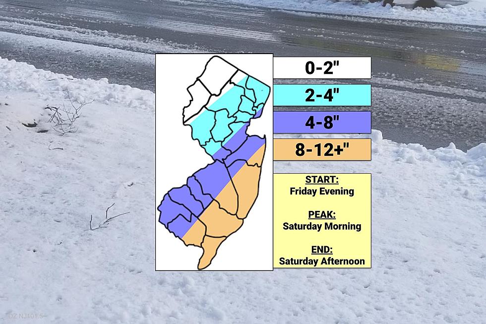
As it stands now, given the data in front of me, the most reasonable and most likely forecast calls for the likelihood of double-digit snowfall across our coastal counties. (A Winter Storm Warning has been issued there.) The Jersey Shore will not only be prone to the heaviest snow bands, but also the strongest winds from this storm.
Let's run through the timeline and wintry impacts. If you scroll down, I've also put together a quick county-by-county breakdown of expected snow totals. To not only illustrate my latest snow map, but also to illustrate the overall uncertainty and the minimum and maximum snowfall possibilities that are still on the table.
Timeline
--Friday mid-morning through early evening... Spotty, occasionally snow showers will creep in from the west, largely unrelated to the coastal storm system. Some reduced visibility, slippery spots, and even a coating of accumulation are possible during the day.
--Friday evening (after 7 p.m.)... It's on like Donkey Kong. Initial snow bands will bubble up from the south, stretching throughout the state by late evening.
--Saturday morning (Midnight to Noon)... The brunt of the storm. Heaviest snow, fastest accumulations, and poorest road conditions will likely occur during this time frame. The winds will really get kicking too, with highest gusts during the daylight hours.
--Saturday afternoon (Noon to 5 p.m.)... Snow will gradually taper off from west to east. Additional (slow) accumulations are possible.
--Saturday evening (after 5 p.m.)... It's all over. As skies clear and winds calm, over a fresh snowpack, it's going to get bitterly cold by Sunday morning. Expect widespread temperatures in the single digits and wind chills potentially below zero.
Snow Forecast, County-by-County
This section contains, for each of New Jersey's 21 counties, three elements:
1.) The "official" snowfall forecast from my latest map from above. (No interpolation, just reiterating the ranges from the image.) Use this number to prepare and plan for the storm.
2.) The lowest-case scenario. My interpretation of the absolute minimum snowfall possible, according to the latest model guidance. (Rounded to the nearest whole inch.)
3.) The worst-case scenario. My interpretation of the absolute maximum snowfall possible, according to the latest model guidance. (Rounded to the nearest whole inch.)
Yes, I realize the wide range of possibilities here is completely absurd. But it paints a picture of the uncertainty baked into this forecast when considering how the storm track may evolve over the next two days.
Atlantic County
--Current Snow Forecast... 8-12+"
--Absolute Minimum Possible Snowfall... 9"
--Absolute Maximum Possible Snowfall... 15"
Bergen County
--Current Snow Forecast... 2-4"
--Absolute Minimum Possible Snowfall... 1"
--Absolute Maximum Possible Snowfall... 8"
Burlington County
--Current Snow Forecast... 4-8" northwest, 8-12+" southeast
--Absolute Minimum Possible Snowfall... 4"
--Absolute Maximum Possible Snowfall... 12"
Camden County
--Current Snow Forecast... 4-8"
--Absolute Minimum Possible Snowfall... 3"
--Absolute Maximum Possible Snowfall... 11"
Cape May County
--Current Snow Forecast... 8-12+"
--Absolute Minimum Possible Snowfall... 9"
--Absolute Maximum Possible Snowfall... 17"
Cumblerland County
--Current Snow Forecast... 4-8" west, 8-12+" east
--Absolute Minimum Possible Snowfall... 6"
--Absolute Maximum Possible Snowfall... 12"
Essex County
--Current Snow Forecast... 2-4"
--Absolute Minimum Possible Snowfall... 1"
--Absolute Maximum Possible Snowfall... 8"
Gloucester County
--Current Snow Forecast... 4-8"
--Absolute Minimum Possible Snowfall... 3"
--Absolute Maximum Possible Snowfall... 11"
Hudson County
--Current Snow Forecast... 2-4" north, 4-8" south
--Absolute Minimum Possible Snowfall... 1"
--Absolute Maximum Possible Snowfall... 11"
Hunterdon County
--Current Snow Forecast... 2-4"
--Absolute Minimum Possible Snowfall... 1"
--Absolute Maximum Possible Snowfall... 6"
Mercer County
--Current Snow Forecast... 2-4" north, 4-8" south
--Absolute Minimum Possible Snowfall... 1"
--Absolute Maximum Possible Snowfall... 6"
Middlesex County
--Current Snow Forecast... 2-4" north and west, 4-8" south and east
--Absolute Minimum Possible Snowfall... 3"
--Absolute Maximum Possible Snowfall... 11"
Monmouth County
--Current Snow Forecast... 4-8" north and west, 8-12+" southeast
--Absolute Minimum Possible Snowfall... 4"
--Absolute Maximum Possible Snowfall... 15"
Morris County
--Current Snow Forecast... 0-2" far northwest, 2-4" for most
--Absolute Minimum Possible Snowfall... 1"
--Absolute Maximum Possible Snowfall... 6"
Ocean County
--Current Snow Forecast... 4-8" far northwest, 8-12+" for most
--Absolute Minimum Possible Snowfall... 6"
--Absolute Maximum Possible Snowfall... 17"
Passaic County
--Current Snow Forecast... 0-2" far northwest, 2-4" central and southeast
--Absolute Minimum Possible Snowfall... 1"
--Absolute Maximum Possible Snowfall... 8"
Salem County
--Current Snow Forecast... 4-8"
--Absolute Minimum Possible Snowfall... 2"
--Absolute Maximum Possible Snowfall... 9"
Somerset County
--Current Snow Forecast... 2-4"
--Absolute Minimum Possible Snowfall... 1"
--Absolute Maximum Possible Snowfall... 8"
Sussex County
--Current Snow Forecast... 0-2"
--Absolute Minimum Possible Snowfall... 0"
--Absolute Maximum Possible Snowfall... 5"
Union County
--Current Snow Forecast... 2-4" for most, 4-8" far east
--Absolute Minimum Possible Snowfall... 1"
--Absolute Maximum Possible Snowfall... 9"
Warren County
--Current Snow Forecast... 0-2"
--Absolute Minimum Possible Snowfall... 0"
--Absolute Maximum Possible Snowfall... 3"
Other Concerns
Wind gusts of 30-40 mph inland and 40-50 mph coast will blow around the dry, fluffy snow. That will lower visibility significantly and cause drifting. The wind may also down trees, branches, and power lines causing sporadic (not necessarily widespread) power outages.
The combination of that fierce wind with cold air will also cause the wind chill (or "feels like" or "apparent" temperature) to dip into "dangerous cold" territory. I could see some wind chills approaching 10-below. Bitter, painful cold.
Minor coastal flooding is also possible during Saturday morning's high tide cycle only, with an extra foot or two of water surging through tidal waterways.
What's Next?
We still have 24+ hours to go until the storm ramps up. And we'll take two more stabs at nailing down the snowfall forecast, the storm timeline, etc.
Next weather blog post will come in the 7 a.m. hour Friday morning. And then we'll take one more hard look at the storm just before it starts late Friday afternoon, around 5 p.m.
As always, if there's any pressing weather or news updates, we'll pass them along on-air, online, and through our free mobile app.
Dan Zarrow is Chief Meteorologist for Townsquare Media New Jersey. Follow him on Facebook or Twitter for the latest forecast and realtime weather updates.
Counting down New Jersey's top 15 weather stories of 2021
The Blizzard of '96 Revisited: Snow totals for every NJ county
More From 105.7 The Hawk


