Henri fly-by for NJ: Inclement weather, angry ocean this weekend
UPDATE... This article is outdated...
For the latest storm forecast information, please refer to my newest weather blog post.
UPDATE as of 5 p.m. Friday...
The National Hurricane Center and National Weather Service have issued a Tropical Storm Watch for the following NJ counties: eastern Bergen, Hudson, eastern Essex, eastern Union, Middlesex, and Monmouth.
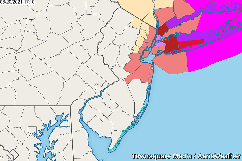
A "watch" is meant to get your attention, suggesting that tropical storm conditions are possible within 36 to 48 hours. In this case, a westward shift in Henri's model guidance means we could see tropical force winds on Sunday — that's 39+ mph.
Keep monitoring the latest forecasts, and keep your weekend plans flexible (especially Sunday). We'll see what happens with the overnight model runs, and see if/when warnings are issued ahead of the storm Saturday morning.
UPDATE as of 3:30 p.m. Friday...
ORIGINAL POST from 6:27 a.m. Friday...
The Bottom Line
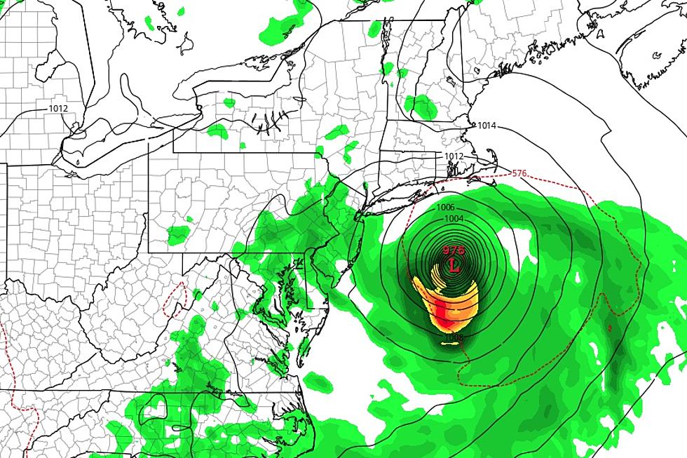
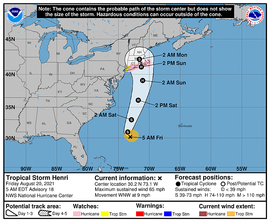
As of Friday morning, Tropical Storm Henri is centered approximately 600 miles south of Cape May, New Jersey. From late Saturday night into early Sunday morning, it is expected to pass about 100-200 east of the Jersey Shore, as a category one hurricane.
So we face inclement, but not particularly dangerous, weather at times through the weekend. Rain, wind, and clouds are in the forecast, no matter where in the state you are. Having said that, we will salvage some breaks of dry weather, especially early Saturday and late Sunday.
The coast is more concerning, due to the threat of rip currents, rough surf, and coastal flooding.
As Henri departs, the heat is on again next week.

Friday
We have some rain in the neighborhood this Friday morning, that is not directly related to Tropical Storm Henri. (You could make the case that Henri is enriching our atmosphere with tropical moisture and enhancing the rain, but it's not the primary driver here.)
The most substantial batches of rain and the wettest weather will be found in southern and central New Jersey through the first half of the day. By mid afternoon, we should be in a solid drying trend - although a few isolated shower or thunderstorms may popup later on.
Rainfall totals will range from a trace (if that) in North Jersey to a spotty inch in South Jersey.
Meanwhile, where it's not raining, it does feel a bit more comfortable than Thursday. Although AM temps are in the 70s, we've stepped down from "truly tropical" humidity levels.
Skies throughout Friday will be pretty overcast, keeping temperatures down. Highs will only reach about 80 degrees in the afternoon. If you catch a pop of sun at some point, a more seasonable 85 is a possibility.
Friday night looks quiet. Mostly cloudy, near 70.
Henri Overview
As Henri makes its closest pass to New Jersey this weekend, our weather will be pretty blah overall. Not a great beach weekend, unfortunately. (And you have no idea how much I hate saying that in the summertime.)
There are no hurricane or tropical storm watches or warnings issued for New Jersey. That alone should be very telling in how severe the storm is expected to be.
Henri's track has been precarious, wiggling back and forth between "no big deal" and "uh oh". There is still a "worst case scenario" in play, which would result in more substantial rain and possibly tropical storm force winds. But the "most likely" consensus forecast is about the same as it has been, pushing Henri's center more toward eastern Long Island, Rhode Island, and Cape Cod than New Jersey.
Bottom line: Henri will absolutely come close enough to spit some rain, wind, and clouds our way. And the ocean will be angry, my friends.
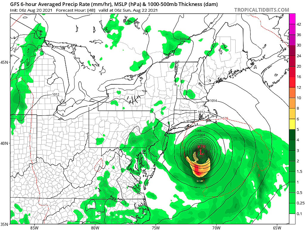
Henri Rain
Over the course of Saturday and Sunday, we'll probably see about two or three bands of rain approach the Shore. However, we will be on the western edge of Henri - that is the dry side of the storm.
More than likely, I suspect the first such band Saturday afternoon will be nothing more than an unimpressive round of splotchy, spotty showers.
The second potential round of rain could be more impactful, as the center of Henri comes closer Saturday night through Sunday morning. I could see some embedded downpours, especially along the coast.
And then the third rain chance during the day on Sunday could be about the same - scattered heavy stuff is possible, but not guaranteed.
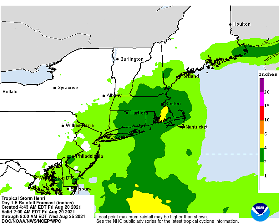
How much rain you see by the end of the weekend is dependent on when and where the heaviest rain bands set up. I've seen guidance show rainfall estimates as low as a quarter-inch (inland). And perhaps as high as 3 inches (coast), if and only if a tropical downpour appears at some point.

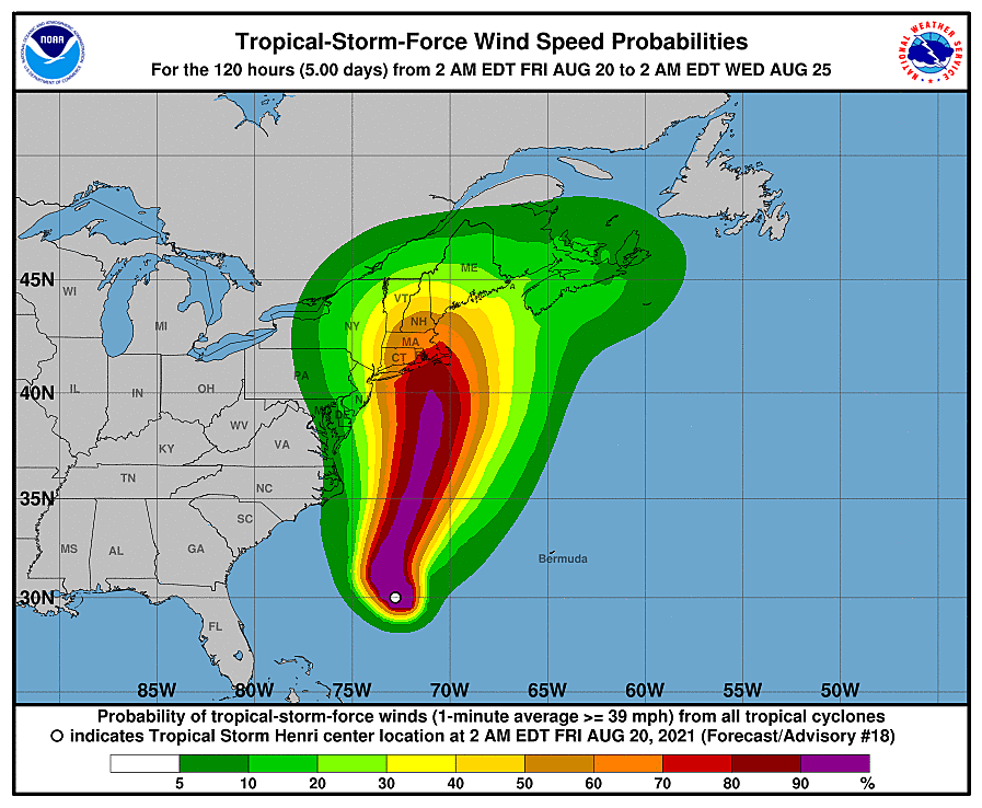
Henri Wind
At the very least, it's going to become "breezy" from Saturday night into Sunday, especially along the eastern edge of New Jersey. Depending on how close the stronger center of Henri's circulation gets, those gusts may approach tropical storm strength (39+ mph). That is enough to blow down some weaker trees and cause sporadic power outages.
Peak winds will blow out of the north-northwest around daybreak Sunday morning.
Henri Severe
As we saw from Fay and Isaias in 2020 and Elsa last month, hurricanes can generate tornadoes. Especially when you're close to the storm's center.
But we won't be near the storm's center - it will stay 100 to 200 miles east. Therefore, the risk of tornadoes in New Jersey will be very low.
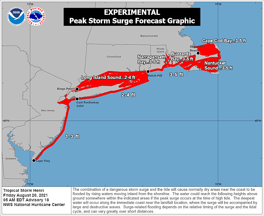
Henri Coast
Most likely, New Jersey's most significant impact from Hurricane Henri will be along the coast.
A high risk of dangerous rip currents is already posted for Cape May and Atlantic counties on Friday. While the official risk level is only moderate for Ocean and Monmouth, that will absolutely bump to high by Saturday. The ocean will remain very rough through Sunday too, before calming significantly on Monday.
I'm seeing the potential for 5 to 8 foot ocean waves, which could cause moderate beach erosion. Not a good development at the tail-end of the summer beach season.
And finally, we have to talk about storm surge and coastal flooding. The latest tidal guidance suggests about a foot of surge (or a little more) will spawn minor coastal flooding for 3 or 4 consecutive high tide cycles. Saturday morning, Saturday afternoon, Sunday morning, and possibly Sunday afternoon.
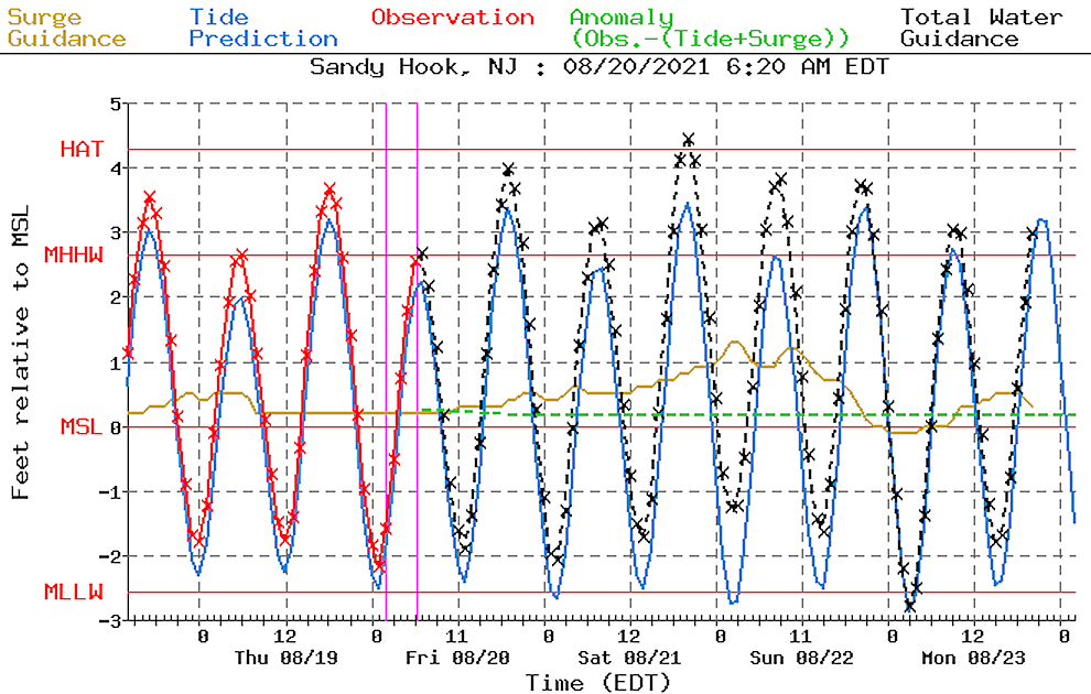
Minor category flooding equates to "the usual spots," that tend to flood during every major storm. Barrier islands, low-lying areas along routes 35 and 36, etc.
Because NJ's strongest winds will be on the backside of Henri, blowing from the north-northwest (not east-southeast), we will be spared even more serious tidal impacts.
The Extended Forecast
.
As Henri exits, we could see drier weather and brighter skies by Sunday late afternoon and evening. High temperatures should reach the lower 80s on Saturday and the seasonable mid 80s on Sunday.
Monday will continue the streak of consecutive "chance of rain" days, with some thunderstorms possibly in the middle of the day. Regardless, our warming trend will continue, with high temps in the upper 80s to around 90 degrees.
While Tuesday and Wednesday look dry, they will also be hot. Thermometers will return to widespread 90s away from the coast. Humidity will be "there" - not too high, but not quite low either. Some model temperatures go as high as 95-96 degrees in urban areas, which could be enough to push the heat index into the "danger zone".
Thursday and Friday look hot and increasingly unsettled. Long-range models have been remarkably stable in showing a strong cold front arriving late Friday. That would introduce thunderstorms, then open the door to some welcome cooler and drier air for next weekend.
Dan Zarrow is Chief Meteorologist for Townsquare Media New Jersey. Follow him on Facebook or Twitter for the latest forecast and realtime weather updates.
Remembering Tropical Storm Irene's impact on NJ, 13 years later
Gallery Credit: Dan Zarrow
Census 2020: The 20 biggest places in New Jersey
Gallery Credit: Michael Symons
8 sharks you may find off New Jersey's coast
Gallery Credit: Dino Flammia
More From 105.7 The Hawk