Friday NJ weather: Cool, misty morning, then brighter afternoon
The Bottom Line
Cool air is back, and it's here to stay for a while. It's going to feel much more November-ish in the coming days. We'll still battle some damp and dreary weather Friday morning, before clearing skies take over. Our next storm system arrives Sunday, with a quick round of rain followed by gusty winds.

Friday
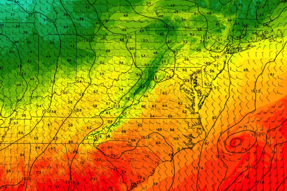
Tropical Storm Eta is passing just east of Charleston, North Carolina as of Friday morning, about 500 miles south of New Jersey. That pesky storm is keeping our atmosphere extra moist, so we start this Friday the 13th damp and dreary. Clouds and mist and fog and drizzle and sprinkles will be over New Jersey (mainly along the coast) through about midday. Then peeks of sunshine will emerge this afternoon. So the day will get brighter and better.
Meanwhile, temperatures are back on the cool side to stay. We're starting the day in the 40s — definitely jacket weather. And high temps will reach the mid 50s — typical for mid-November. A far cry from the last week of 70s, of course.
We also descend into potential frost territory Friday night. As skies continue to clear, thermometers will dip into the upper 30s on average. I don't think it will get cold enough for a widespread freeze. But 37-ish is cold enough for a frost — so you might see some ice crystals on grass, vegetation, and your car windshield early Saturday morning.
Saturday
Bright and sunny, but cool. High temperatures in the lower 50s will be slightly below normal. Not bad.
Sunday
The first half of the day looks fine. It will be a bit warmer, with highs jumping to about 60 degrees. The morning will progress from sun to clouds.
And then our next storm system, a cold front, will arrive in the afternoon hours. (This forecast timeline has slid a bit earlier.) That will drive a quick round of rain through the state, from west to east. (By quick, I mean the wet weather will only last a couple of hours, at the most.) Raindrops may begin as early as 2 p.m., and could linger along the coast as late as 10 p.m.
Behind that front, even colder air. And as it typical in the fall, that colder air will whoosh in on a gusty west-northwest wind Sunday night into Monday.
Monday
Wind gusts on Monday could reach a garbage can toppling 40 mph. It will be sunny, but cool and blustery. High temperatures will descend to the lower 50s.
Tuesday & Beyond
Colder air will really settle in through the middle of next week, thanks to a reinforcing shot of cool air on Tuesday. That little front could even spark some snow showers in the morning, especially around northern NJ.
Highs on Tuesday will be limited to around 50 degrees. And then Wednesday looks like the bottom of the barrel, with highs barely topping 40 degrees. That's kind of mind-boggling — after all, this past Wednesday, we were basking in record-breaking 70s! What a difference a week makes, huh?
Have a great weekend!
Dan Zarrow is Chief Meteorologist for Townsquare Media New Jersey. Follow him on Facebook or Twitter for the latest forecast and realtime weather updates.
The 10 Best Sunrises in Seaside Park
More From 105.7 The Hawk


