Flash Flood Watch: Heavy rain, severe storms could prove precarious for NJ
UPDATE as of 8 p.m. Wednesday...
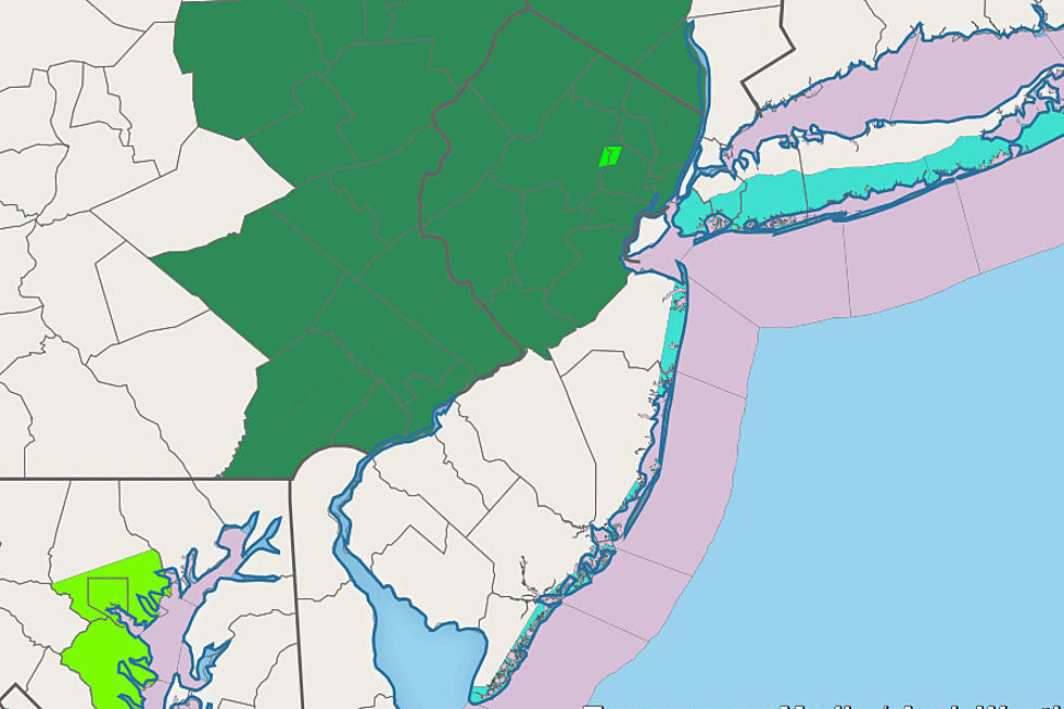
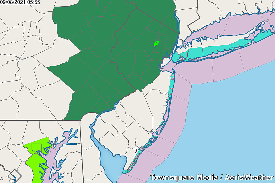
A Severe Thunderstorm Watch has been issued for eight counties in northern and western New Jersey until Midnight. Included in the watch are Bergen, Passaic, Morris, Sussex, Warren, Hunterdon, and Mercer counties.
A "watch" is a formal heads-up that severe weather - including wind, hail, and tornadoes - is possible within the next few hours. If such conditions do develop, warnings would be issued.
A Flash Flood Watch continues for approximately the northern half of New Jersey too. The incoming storms have produced 1 to 1.5 inches of rain over eastern Pennsylvania, right on the forecast target. That's enough to cause brief bouts of flash (road) flooding. But river levels are only expected to rise a few inches (if that) from such rainfall.
UPDATE as of 2 p.m. Wednesday...
After looking through the latest model data, I have some updates to share. Nothing breaking and new, just further pinpointing the timeline and significance of Wednesday evening's rain:
—Why is this a big deal? Northern and central New Jersey are in a precarious position due to the lingering impacts of Ida. If not for full waterways, soggy ground, still-flooded basements, and compromised storm drains, I doubt we would be taking this inch-plus rain event quite as seriously.
—Wednesday's first round of spotty thunderstorms will peak in the evening hours, between about 4 p.m. and 8 p.m. There is a risk for some severe weather, meaning wind, hail, and/or a tornado. Especially along the western edge of the state.
—The second round of rain will be "the main event," with a push of moderate to heavy rain. It looks like the heaviest rain will impact waterlogged northern half of New Jersey right around or just after Midnight.
—Top rainfall totals still look to max out between 1 and 2 inches. 6-hour flash flood guidance is also running around an inch or less from Mercer and Middlesex counties north. Hence, the need for a Flash Flood Watch.
—There is a third round of rain possible for Thursday, leading to an overall wetter and drearier day than originally thought. Most models now keep scattered rain for at least the coast through part of the afternoon.
—By the way, there could be some downpours in South Jersey, especially as this storm system wraps up on Thursday. But because the southern half of NJ was largely spared from the heavy rain of Ida last week, flash flooding is not expected to be a widespread problem there.
Keep reading (and stay tuned) for more details on this "precarious" wet weather forecast...
ORIGINAL POST from 6:21 a.m. Wednesday...
The Bottom Line
Let me be crystal clear right off the bat here: This weather situation will absolutely not be a repeat of Ida's widespread destruction exactly one week ago. It is not going to rain 8 inches within 4 hours. Not even close.
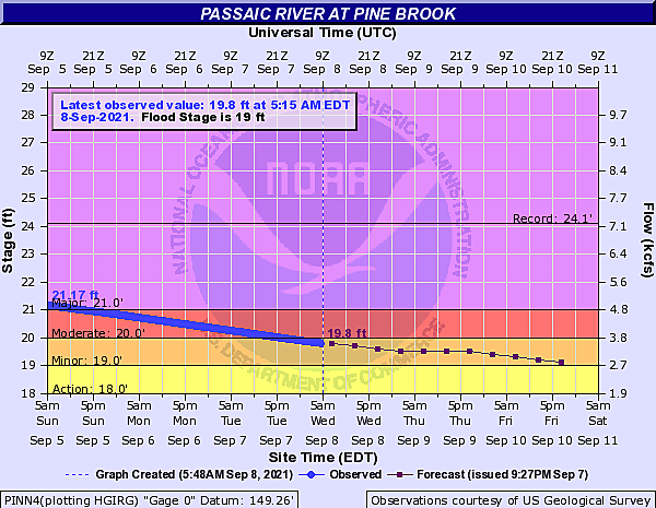
However, with a forecast of 1 to 2+ inches of rain in play, we have to keep our current status in mind. (Called "antecedent" conditions.) Many communities across New Jersey are still a mess. Flood warnings continue for the Passaic River through Morris, Passaic, and Essex counties, with water levels still running just above flood stage. And unfortunately, that is the exact corner of the state most likely to see heavy rain from Wednesday evening's storm system.
There is also a non-zero chance of tornadoes here. And as we've seen 13 times so far in 2021, that's nothing to ignore.

When? Storm Timeline
Wednesday will start off quiet, with an uptick in humidity. Look for partly sunny skies through midday, with high temperatures in the lower-mid 80s.
Between about 2 p.m. and 8 p.m. Wednesday, a round of spotty showers and thunderstorms is expected over New Jersey. These hit or miss storms may become strong or severe, given our warm and humid atmosphere. Gusty winds, pockets of heavy rain, frequent lightning, and even an isolated tornado are possible.
Between about 8 p.m. Wednesday and 3 a.m. Thursday, the "main event" will precede a cold frontal passage. One or two bands of moderate to heavy rain will sweep generally from northwest to southeast across the state. This will be the period of the most widespread downpours, and the highest flash flooding risk.
Rain showers may linger through much of Thursday, especially along the coast. That will be followed by clearing skies and beautiful weather through the upcoming weekend.
Where? Greatest Flooding Risk
As I mentioned, heavy rain plus saturated ground and swollen rivers equals flooding. That's clearly our biggest concern over the next 24 hours.
Forecast models are fairly consistent in putting a swath of 1-2+ inches across part of northern New Jersey. (In past runs, some estimates have gone as high as 3+ inches, which is pretty serious.) Additional inch-plus heavy rain may develop over more-humid southern NJ too.
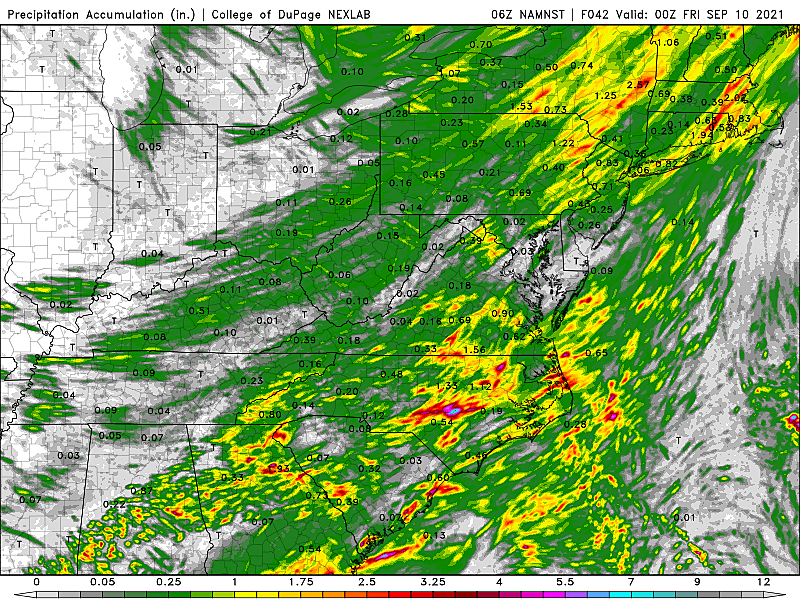
Under normal circumstances, such rainfall would warrant alarm bells only for poor travel conditions due to ponding issues and low visibility. However, the latest flash flood guidance from the Mid-Atlantic River Forecast Center suggests that only 1 to 2 inches of rain is necessary to cause flash flooding across the waterlogged northern half of the state. (For the record, that number is much higher in South Jersey, which is why the flooding concern is much lower.)
Additionally, waterways are still running high in many spots. Specifically, the Passaic River is still just above flood stage, after cresting this weekend.
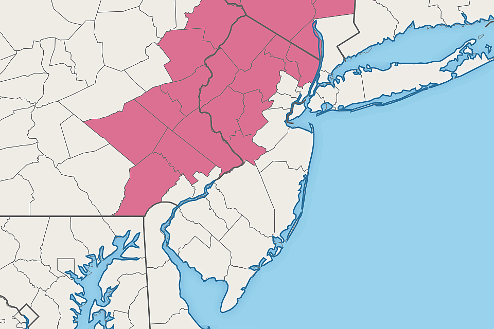
A Flash Flood Watch has been issued for Mercer-Middlesex on north, in effect from Wednesday afternoon through early Thursday morning. That means flash flooding conditions are possible, although not imminent. That's what a warning is. (For the record, I think the geography of this watch is spot on, given the factors I laid out above.)
Bottom Line: More rain and runoff is exactly what northern New Jersey does not need right now. It's not going to be "another Ida" in terms of almost a foot of rainfall and record flooding. However, flash flooding and river flooding could again be issues for some areas where the ground is saturated and where it really pours. If you had water issues last week, it would be worthwhile to pay extra attention to weather conditions and warnings Wednesday evening.
Where? Greatest Severe/Tornado Risk
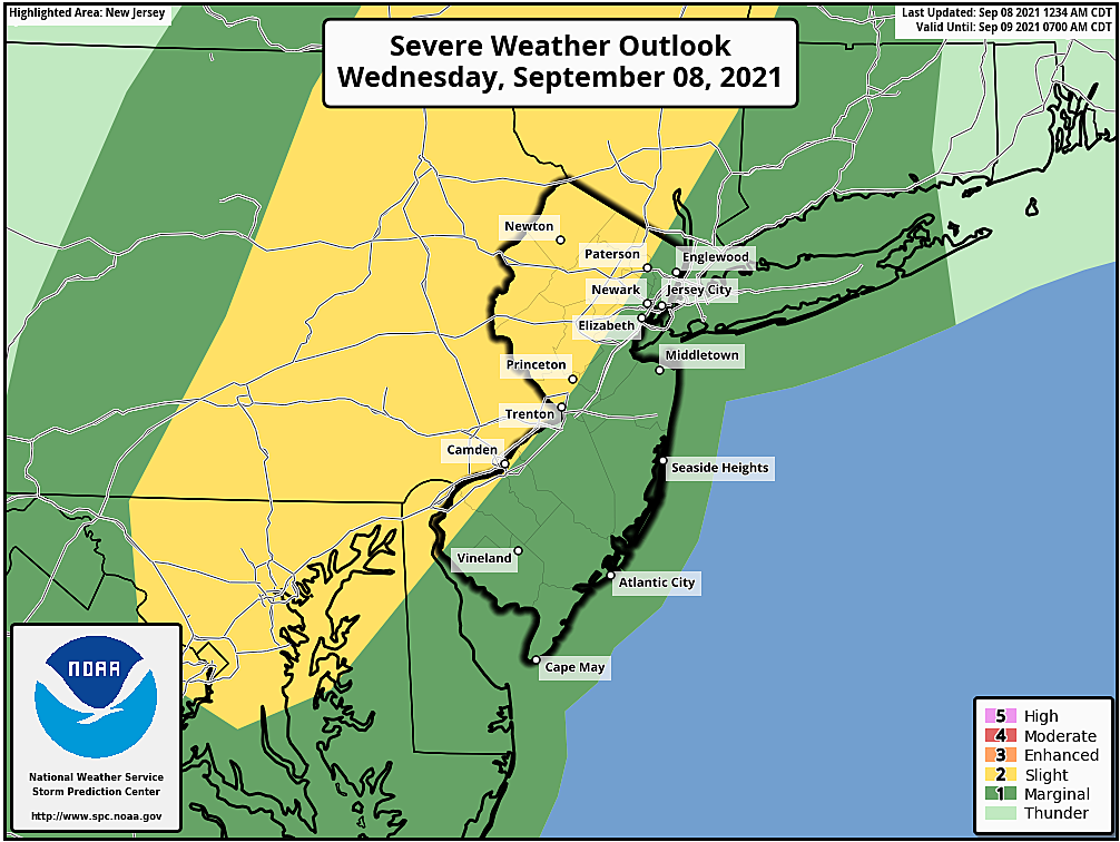
Given the timing and orientation of both rounds of potential thunderstorms, and the associated severe weather parameters, the best chance for a stronger, potentially tornadic storm will be along the western edge of New Jersey. Sussex, Warren, Hunterdon, Mercer, Burlington, Camden, Gloucester, and Salem counties, I'm looking at you.
In fact, the Storm Prediction Center has painted a good chunk of northern and western NJ in a "Slight Risk" (level 2 of 5) in the Wednesday severe weather outlook. The rest of the state falls under a "Marginal Risk" (level 1 of 5) for severe wind, hail, and/or tornadoes.
I would not be surprised to see a severe thunderstorm or tornado watch issued for part of New Jersey just before storms begin popping.
What Else? Hurricane Larry
You may have heard that Hurricane Larry is spinning in the middle of the Atlantic Ocean, over 1,300 miles southeast of the Jersey Shore. A powerful category 3 major hurricane, it is aiming to brush past Bermuda on Thursday as it curving out to sea.

Although Larry poses no direct threats to the U.S. East Coast, a period of big waves and rough surf is expected. A high risk of rip currents is already posted for the Jersey Shore Wednesday.
Other than all that, our weather looks issue-free and quite pleasant through the upcoming weekend. Our next chance of rain would be spotty showers Sunday night.
Final Thoughts
Take a deep breath, New Jersey. We've had a ton of crazy weather lately — not just from Ida last week, but really all summer long. Hopefully you get the sense that Wednesday evening's cold front poses some risks that should be taken seriously. But the chance of another "historic" and "record-breaking" storm is low this time around.
You know the forecast and the risk level — that's half the battle. Now we just take it one raindrop at a time. Be smart and stay safe out there.
Dan Zarrow is Chief Meteorologist for Townsquare Media New Jersey. Follow him on Facebook or Twitter for the latest forecast and realtime weather updates.
Incredible, heartbreaking images of Ida's damage in New Jersey
Gallery Credit: Dan Alexander
BEEP BEEP BEEP: These are the 13 types of Wireless Emergency Alerts auto-pushed to your phone
Gallery Credit: Dan Zarrow
More From 105.7 The Hawk