NJ will be clipped by snowy, rainy, windy nor’easter Monday-Tuesday
UPDATE... This article is outdated...
For the latest storm forecast information, please refer to my newest weather blog post.
The Latest Update
Since my last full forecast update on Saturday, not much has changed. A powerful "Miller Type B" nor'easter will impact the Northeast United States from now through midweek. Here in New Jersey, that means we face approximately 36 to 48 hours of active, inclement weather.
Yes, accumulating snow is on the table. So is rain. And wind. The big question is just how much snow will be able to fall and accumulate. Especially since surface temperatures for the duration of this storm will remain above freezing.
The bottom line: Sunday night into Monday will be primarily wet. Monday night into Tuesday will be at least partially wintry. But no meteorologist and no model out there has a "crystal ball" to know exactly how this is going to play out right now. It's too close a call, with too many variables in play. Period, full stop.
This article serves to take a first stab at a public snow accumulation map. I'm not confident or happy about it. But with just over 24 hours to go until the brunt of the storm begins, it is a starting point. My numbers are somewhat more aggressive than some forecasters (including the National Weather Service). But I'm also throwing certain wildly overdone forecast models out the window. (Ahem, the NAM.)
Let's jump in to the latest details, which will continue to grow in clarity and certainty.

Timeline
—Part 1 (Sunday night)... Rain showers are already pushing into southwestern New Jersey as of this writing. We will see spotty raindrops through the overnight hours.
—Part 2 (Monday)... Scattered rain will continue to fall over almost all of New Jersey. There is a chance for some early snowflakes in the NW corner of the state, with up to an inch of accumulation. But even that piece of NJ will flip to plain rain for most of the state.
—Part 3 (Monday night)... Between about 9 p.m. and 3 a.m., temperatures will drop enough for a transition from rain to snow. This will be the brunt of the storm. For northern New Jersey at least, snowfall may be heavy at times, leading to (eventual) accumulations and treacherous travel conditions. To the south, dry air will probably start to drive in, putting an early end to precipitation in South Jersey.
—Part 4 (Tuesday)... Periods of snow ongoing at daybreak. If there's going to be a snow day for North Jersey, this would be it. Periods of snow may continue for much of the daytime hours, especially to the north and east. (The exact end time of snow is one of the big question marks in this forecast.)
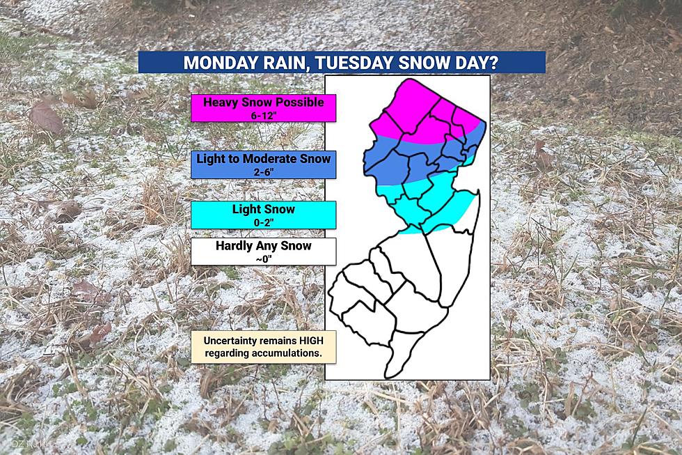
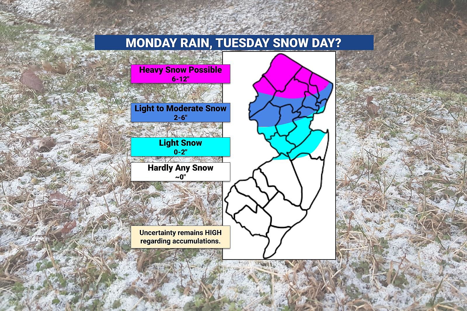
Accumulations
—Far North Jersey (magenta)... I am still pretty confident that somewhere northeast of NJ will see over a foot of snowfall from this storm system. Will that area of heavy snow accumulations clip the northern edge of the Garden State? I think so. 6 to 12 inches seems like a good estimation here, even considering the wet nature of the snow and just above freezing air/soil temperatures.
—North-Central Jersey (dark blue)... This band is still in the "unknown zone," as a little wiggle in the storm track of a few miles can make a huge difference in how much snow falls. Again, above freezing temperatures will be a challenge - but that challenge can be overcome by one band of heavy snowfall. 2 to 6 inches is my official call here, an admittedly wide range. But I have seen estimates as low as zero and as high as a foot - I would say both of those options are equally possible in this zone. I look forward to presenting a much more refined forecast soon.
—Central Jersey (light blue)... You will probably see some snow during the late stages of this storm. And especially during the day on Tuesday, icy spots and accumulations are possible. Up to an inch. Just like I mentioned above, this piece of the forecast is especially low confidence.
—South Jersey (white)... This will not be a snow storm south of I-195. There may be some flakes mixed in with raindrops at times on Tuesday, but little to no accumulation is expected.
Other Impacts
—Travel... In a worst-case scenario, snowy roads and low visibility could make for dangerous driving conditions. Flights may be delayed or canceled. And, as long as the snowy forecast holds, there is a good chance for school closures in North Jersey (at least) on Tuesday.
—Wind... The strongest winds will blow from the northwest after the storm departs, Tuesday into Wednesday. Gusts over 40 mph are possible.
—Coastal Flooding... One round of coastal flooding is expected during high tide Monday night-Tuesday morning, during the brunt of the storm. Minor category only.
—Beach Erosion... Wave heights could peak around 6 to 8 feet, leading to moderate beach erosion along the Jersey Shore. A typical impact of strong nor'easter storm systems like this one.
Advisories
A Winter Storm Watch is in effect for Sussex County from 6 a.m. Monday until 8 p.m. Tuesday. A watch covers western Bergen and western Passaic counties from 7 p.m. Monday until 7 p.m. Tuesday.
If the 6+ inch snow forecast continues for that area, watches will be upgraded to warnings before onset.
Less urgent, less severe advisories will be issued for part of the state too, which cautions of treacherous travel and 2-3+ inches of snow.
Again, once the storm forecast firms up a bit more, we will have a better picture of the potential impacts.
What's Next?
We'll give this snow forecast another try Monday morning. Next full forecast update will hopefully be published by 8 a.m. If needed, one more web update will be pushed out Monday afternoon/evening, before the snow fun begins.
Of course, you can always flick on your radio for instant weather, traffic, and news. I'll have regular updates starting at 4:33 a.m. Monday.
Be sure to download our mobile app for the latest info too.
Dan Zarrow is Chief Meteorologist for Townsquare Media New Jersey. Follow him on Facebook or Twitter for the latest forecast and realtime weather updates.
Let it snow: 12 things to know about winter forecasting in NJ
BEEP BEEP BEEP: These are the 13 types of Wireless Emergency Alerts auto-pushed to your phone
More From 105.7 The Hawk