
NJ winter storm update: Who will be in the snowfall sweet spot?
The Forecast
While most of Saturday's daytime hours will be chilly and quiet, a coastal storm system is set to impact New Jersey from late afternoon through early Sunday morning. Temperatures will be very close to the freezing mark throughout the storm, leading to a wintry mess of snow (mainly NW) and rain (mainly SE). While it may take a while for this heavy, wet snow to stick to road surfaces, travel-inhibiting snow accumulations are possible for much of the state.
This remains an exceptionally tricky forecast, and model consensus remains pretty poor. The question I posed in the headline of this article is somewhat rhetorical — crafting a perfectly precise and accurate forecast for this kind of situation is impossible, and practically requires us to defy modern science. There will be places where the difference of a single degree on the thermometer can make all the difference between "boom" and "bust". (I highly recommend you read my Friday evening weather blog for more brutally honest details on the forecast challenge here.)
You'll find two significant changes since my last forecast update: 1.) adjusted the storm timeline earlier by a couple hours, and 2.) scaled back snow totals slightly (especially for the southern half of the state).
Timeline
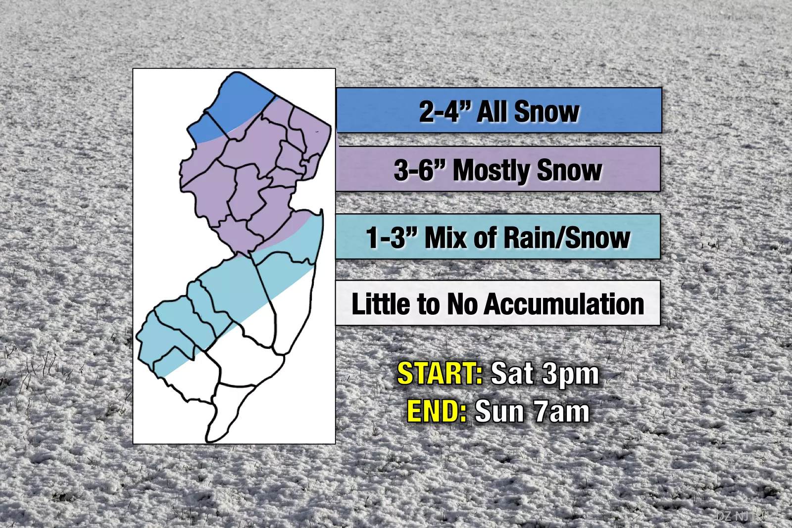
--3 p.m. to 5 p.m. Saturday: First snowflakes and raindrops enter New Jersey
--7 p.m. Saturday to Midnight Sunday: Peak of the storm, time of heaviest snow and rain
--4 a.m. to 7 a.m. Sunday: Snow/rain tapers off as storm system exits the coast
Totals
--Cold, but Light (2-4"): Far northern New Jersey will be cold enough to sustain all snow, but is expected to fall outside of the heaviest snow bands. Air temperature: 28 to 32 degrees.
--The Sweet Spot (3-6"): The heaviest snow and highest potential totals are expected to occur in a stripe along and just northwest of the NJ Turnpike. Note: if substantial rain creeps into this area, there's no way we'll see a half-foot of snow. Additional note: I seriously considered lowering the upper bound of this region to 5", but ultimately decided to leave it alone due to the expected intensity of snowfall (a solid "thumping"). Air temperature: 30 to 35 degrees.
--Heavy, but Warm (1-3"): While southern New Jersey will be closest to the center of this potent little storm, temperatures are expected to be just above freezing for most of the overnight. As you would expect, that will lead to more rain/mix than straight snow. Air temperature: 32 to 36 degrees.
--Mostly Rain (0-1"): Along the south coast, temperatures will likely hover above-freezing all night. There could be some snow and sleet mixed in here. But this are alf the state looks mostly wet and not wintry. Air temperature: 34 to 40 degrees.
Advisories
As expected, early Saturday morning, the National Weather Service issued their suite of warning and advisory products for this storm. The NWS office in Mt. Holly (which covers most of NJ) opted for a Winter Weather Advisory. The NWS office in Upton, N.Y. (which forecasts for the 5 counties in NE NJ) issued a more severe Winter Storm Warning.
Upton's snow forecasts have been among the highest of all forecasters in the region for this storm. In my professional opinion, given the low snow ratio and poor phasing of this storm, their big totals and warning are misplaced and overdone. It's going to be exceedingly difficult to get snow totals over 6 inches (the general warning threshold) in New Jersey.
--Winter Storm Warning (4-7") from 5 p.m. Saturday to 7 a.m. Sunday for Bergen, Essex, Hudson, Passaic, and Union counties.
--Winter Weather Advisory (2-5") from 4 p.m. Saturday to 4 a.m. Sunday for NW Burlington, Camden, Gloucester, Hunterdon, Mercer, Middlesex, inland Monmouth, Morris, Salem, Somerset, Sussex, and Warren counties.
Impacts
No matter what falls from the sky — snow, rain, or a combination of both — road conditions are going to get pretty messy during the height of the storm Saturday night. During periods of heavy snowfall, visibility may be severely reduced.
If you do see accumulations, be aware the snow is going to be very heavy and therefore difficult to shovel. As you venture out to clear your driveway and sidewalk, be extra careful to not overexert yourself and take frequent breaks.
There's a decent chance that church services and other community activities will be delayed or cancelled Sunday morning, especially in the snowfall "sweet spot" through northern and central New Jersey.
Final Thoughts
If this forecast turns out to be a total bust, and only an inch or two of snow falls over New Jersey, the GFS model will be the hero of the day. I will not be completely surprised, but I will be supremely disappointed.
If 7+ inches of snow falls in New Jersey, NWS Upton will emerge victorious. Ha.
Again, I can't stress this enough... Please look beyond the concrete forecast numbers. Weather conditions are going to get yucky — even downright dangerous. No, it's not a "major" winter storm. No, you don't need to stock up on "french toast" supplies. And yes, any snow accumulation will melt quickly in Sunday's 50-degree air.
Please take this wintry mess seriously, especially if you have any intention of going out Saturday night through Sunday morning.
More From 105.7 The Hawk


