
Light snow this weekend: Minor to moderate travel impacts for NJ
Really, not much has changed since my Thursday morning posting. But that's a good thing! When forecast models show solid run-to-run consistency, it adds to forecast confidence. While most of New Jersey should expect nothing more than "conversational snow" over the weekend, we still need to consider a potential storm "wiggle" of about 50 miles.
Here are 8 bullet points reviewing this weekend's minor snow forecast:
Friday-Saturday... Just plain cold. Friday is starting cold and blustery, with temps in the 20s and painful wind chills in the teens. Highs will only reach the lower to mid 30s. Luckily, the biting breeze will eventually calm down. Of course, the combination of clear skies, bone-dry air, and light winds will make for a very cold Friday night and Saturday morning, with forecast low temperatures in the upper teens to around 20 degrees. As clouds increase Saturday, highs will once again be limited to about 30 to 35 degrees.
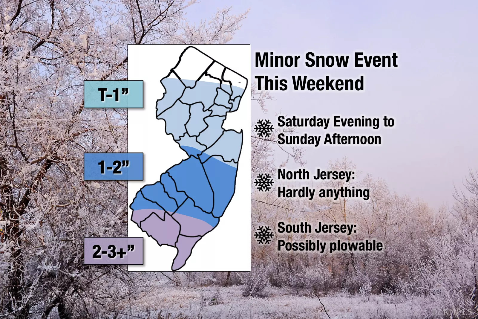
Snow Timeline... First snowflakes are expected to drift into SW NJ in the early evening hours on Saturday, spreading northward through the late evening and overnight. Periods of moderate snow will be possible through Sunday morning. I'm more confident now that snowfall will taper off Sunday afternoon. Perhaps with a quick splash of mixing and/or rain as temperatures bump just above the freezing mark. Let's just leave the possibility alive that an additional snow band may clip southern New Jersey through Sunday evening too. But the chance of snow showers lingering into Monday morning is now unlikely (thankfully).
Snow Totals... I adjusted my latest snow map slightly: adding a "little to no snow" area in far North Jersey, reducing South Jersey's max snow from 6 inches to 3+ inches, and generally flattening my contour lines. Could we still see 4, 5, 6, or more inches of snow in South Jersey? Absolutely, a heavier snow band could easily accomplish that. A storm wiggle to the north could do that too. But once again, we have to look at the preponderance of model guidance pointing toward the most likely outcome: no more than about 3 inches in southern New Jersey.
No Big Wind... The strongest part of this storm system will pass well south of New Jersey, so it's not going to turn truly stormy or nasty. I'm showing "breezy" conditions for Sunday, with gusts to about 20 mph.
Insignificant Coastal Flooding... Given the lack of any strong on-shore flow, we're not going to face the traditional surge of water against the Jersey Shore. The fact that we have a waxing crescent moon and generally low astronomical tide now also helps. (A new moon or full moon would produce higher tides.) While I do see slightly elevated water levels in Sunday's high tide forecast, I wouldn't even put the potential rise in the "minor" category.
After the Storm... Skies could clear as early as late-day Sunday, and we'll certainly sunshine take over by Monday. Temperatures are going to stay cold for the foreseeable future, however. Mid 30s Monday. Upper 30s to around 40 on Tuesday. The warmest day of next week — in fact, our only substantially above-normal day — will be Wednesday, as southwesterly winds push high temps into the lower to mid 40s.
Next Snow Chance... Long-range models suggest some snow showers around the Garden State on Wednesday night and again on Friday. Our next "big" storm threat is currently showing up for next weekend — way too early for details, we'll take a closer look next week.
Coverage Plan... The threat for a monster, crippling snowstorm has been off the table for a few days now. However, I'm still concerned about minor to moderate travel impacts during and after the storm. Our news, traffic, and weather teams are on alert this weekend, and we'll continue to bring you the latest information. Unless things shift dramatically, I'm planning once-daily weather blog updates: Saturday morning, and again Sunday morning.
Be smart, stay safe, and have a great weekend!
More From 105.7 The Hawk


